AHGW:Create XS2D Borelines
From XMS Wiki
Jump to navigationJump to search
The Create XS2D Borelines tool is accessed by double-clicking on "![]() Create XS2D Borelines" under the "
Create XS2D Borelines" under the "![]() XS2D Editor" toolset under the "
XS2D Editor" toolset under the "![]() Subsurface Analyst" toolset under the "
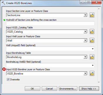
Subsurface Analyst" toolset under the "![]() Arc Hydro Groundwater Tools" toolbox. This tool imports boreline features for display on a 2D cross section by reading from a layer of wells and a table of borehole information associated with the wells. The boreline features reveal stratigraphy observed in the wells, and include attributes providing the distance from the section line defining the cross section and the distance along the section line.
Arc Hydro Groundwater Tools" toolbox. This tool imports boreline features for display on a 2D cross section by reading from a layer of wells and a table of borehole information associated with the wells. The boreline features reveal stratigraphy observed in the wells, and include attributes providing the distance from the section line defining the cross section and the distance along the section line.
The following fields are available. Required fields are marked with a ![]() icon. Fields marked with a
icon. Fields marked with a ![]() icon may either not be supported or the table doesn't exist.
icon may either not be supported or the table doesn't exist.
- Input Section Line Layer or Feature Class – Click the
 button to bring up the Input Section Line Layer or Feature Class dialog in order to specify the layer or feature class containing the section line defining the cross section for which features are to be created.
  HydroID of Section Line defining the cross section – Enter the numerical ID uniquely identifying the section line feature defining the cross section.
- Input XS2D_Catalog Table – Click the
 button to bring up the Input XS2D_Catalog Table dialog in order to specify the XS2D_Catalog table. The table is defined as part of the Arc Hydro Groundwater Data Model, and is used to manage XS2D feature classes.
 - Input Well Layer or Feature Class – Click the
 button to bring up the Input Well Layer or Feature Class dialog in order to specify the well features for which borelines will be created. If you are using ArcMap, this tool will only use selected features if a selection has been made on the layer.
 - Well UniqueID field – Optional. Select from the drop-down the field specifying the Unique ID (ex. HydroID) of the Well features. This value will be related to the Well ID parameter for the BoreholeLog table. If no field is specified, then the HydroID field will be used.
- Input BoreholeLog Table – Click the
 button to bring up the Input BoreholeLog Table dialog in order to specify the table that stores vertical measurements defining the stratigraphy for wells. The TopElev and BottomElev fields in this table are used to define the geometry for the output boreline features.
 - BoreholeLog WellID field – Optional. Select from the drop-down the field specifying the Well ID (ex. WellID) of the BoreholeLog table. This value will be related to the Unique ID (ex. HydroID) of the Well features. If no field is specified, then the WellID field will be used.
- Input XS2D Boreline Layer or Feature Class – Click the
 button to bring up the Input XS2D Boreline Layer or Feature Class dialog in order to specify the layer that will store the boreline features that are created. If this layer does not already exist, it can be created using the Create XS2D Boreline Feature Class tool.
 - Overwrite – Turn on to clear the target feature class prior to creating new BoreLines. Turn off to append new BoreLines to the target feature class.

