User:Rcorrigan/AHGW Pro:Create Borelines
From XMS Wiki
Jump to navigationJump to search
The Create BoreLines tool is accessed by double-clicking on "![]() Create BoreLines" under the "
Create BoreLines" under the "![]() Features" toolset under the "
Features" toolset under the "![]() Subsurface Analyst" toolset under the "
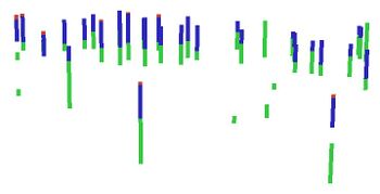
Subsurface Analyst" toolset under the "![]() ArcHydroGroundwater.pyt" toolbox. This tool creates BoreLine (3D polyline) features from vertical data related to point features (e.g. Wells). Tool inputs are a point feature class and a table with vertical data, which are related through key fields. Features can be attributed with a GroupID which can be used to categorize the BoreLines (for example, into hydrogeologic units).
ArcHydroGroundwater.pyt" toolbox. This tool creates BoreLine (3D polyline) features from vertical data related to point features (e.g. Wells). Tool inputs are a point feature class and a table with vertical data, which are related through key fields. Features can be attributed with a GroupID which can be used to categorize the BoreLines (for example, into hydrogeologic units).
- ArcGIS Notes – In older versions of ArcGIS, this tool appears as a dialog and is accessed through the "Arc Hydro Groundwater Tools" toolbox.
- The icons vary between ArcGIS and ArcGIS Pro.
- The names of the fields for this tool might be different in ArcGIS.
The following fields are available. Required fields are marked with a ![]() icon. In ArcGIS, they are marked with a
icon. In ArcGIS, they are marked with a ![]() icon. Fields marked with a
icon. Fields marked with a ![]() icon may not be supported or the selected table may not exist.
icon may not be supported or the selected table may not exist.
- a
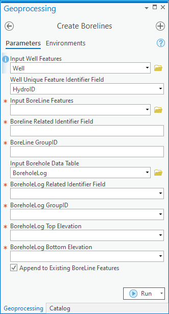
 Input Well Features – Click the
  button to bring up the Input Point Features dialog in order to specify the point features representing the location where the borehole data were measured.
 - a
 Unique Point Identifier Field – Select from the drop-down the unique identifier of the point features. The unique identifier is used as a key field to which vertical data are related.
 - a
 Input BoreLine Features – Click the
  button to bring up the Input BoreLine Features dialog in order to specify the feature class storing the 3D features created.
 - a
 BoreLine Related Identifier – Select from the drop-down the key field associating BoreLine features to the point features from which they were created.
 - a
 BoreLine GroupID – Select from the drop-down the attribute of BoreLine features used to classify them into categories (e.g., hydrogeologic units).
 - a
 Input BoreholeLog Table – Click the
  button to bring up the Input BoreholeLog Table dialog in order to specify the table containing vertical data from which the BoreLine features are created.
 - a
 BoreholeLog Related Identifier – Select from the drop-down the key field associating vertical data with point features.
 - a
 BoreholeLog GroupID – Select from the drop-down the field in the attribute of the BoreholeLog table used to classify intervals into categories (e.g., hydrogeologic units).
 - a
 BoreholeLog Top Elevation – Select from the drop-down the field in the BoreholeLog table representing top elevations.
 - a
 BoreholeLog Bottom Elevation – Select from the drop-down the field in the BoreholeLog table representing bottom elevations.
 - Append to Existing BoreLine Features – Optional. Turn on to append new BoreLines to the feature class. Turn off to clear the target feature class prior to creating new BoreLines.


