User:Rcorrigan/AHGW Pro:Desurvey Borelog
The Desurvey Borelog tool is accessed by double-clicking on "![]() Desurvey Borelog" under the "
Desurvey Borelog" under the "![]() Features" toolset under the "
Features" toolset under the "![]() Subsurface Analyst" toolset under the "
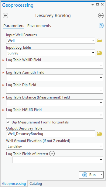
Subsurface Analyst" toolset under the "![]() Arc Hydro Groundwater Tools" toolbox. This tool reads a table of bore log data, and desurveys the data into another table for later processing. The bore log contains dip and azimuth values which can be later used for constructing non-vertical boreline features. Desurveying is the process of translating survey data (azimuth, dip, length) of non-vertical boreholes into XYZ coordinates and point order for points along a non-vertical borehole in order to define the 3D geometry of the non-vertical borehole.
Arc Hydro Groundwater Tools" toolbox. This tool reads a table of bore log data, and desurveys the data into another table for later processing. The bore log contains dip and azimuth values which can be later used for constructing non-vertical boreline features. Desurveying is the process of translating survey data (azimuth, dip, length) of non-vertical boreholes into XYZ coordinates and point order for points along a non-vertical borehole in order to define the 3D geometry of the non-vertical borehole.
- ArcGIS Notes – In older versions of ArcGIS, this tool appears as a dialog and is accessed through the "Arc Hydro Groundwater Tools" toolbox.
- The icons vary between ArcGIS and ArcGIS Pro.
The following fields are available. Required fields are marked with a ![]() icon. In ArcGIS, they are marked with a
icon. In ArcGIS, they are marked with a ![]() icon. Fields marked with a
icon. Fields marked with a ![]() icon may either not be supported or the table doesn't exist.
icon may either not be supported or the table doesn't exist.
 Input Well Features – Click the
  button to bring up the Input Well Features dialog in order to specify the Well features, part of the Arc Hydro Groundwater Data Model. The wells point features are used as starting XY (and optionally, Z) values for desurveying the log.
 Input Log Table – Click the
  button to bring up the Input Log Table dialog in order to specify the bore log table, containing the measurement data such as azimuth, dip, and depth.
 Log Table WellID Field – Select from the drop-down the field in the log table which relates back to the HydroID field of the Well features.
 Log Table Azimuth Field – Select from the drop-down the field in the log table containing the azimuth measurements of the bore log.
 Log Table Dip Field – Select from the drop-down the field in the log table containing the azimuth measurements of the bore log. The dip value can be measured either from horizontal or vertical, and is specified in another parameter.
 Log Table Distance (Measurement) Field – Select from the drop-down the field in the log table containing the length of a particular observation from the borelog.
 Log Table HGUID Field – Select from the drop-down the field in the log table containing the Hydrogeologic Unit ID (or other attribute) used to describe the material of the observation.
- Dip Measurement from Horizontal – Turn on if the dip measurement is from horizontal, where horizontal is zero degrees and straight down is -90 degrees. Turn off if the dip measurement is from vertical, where straight down is zero degrees and horizontal is -90 degrees.
- Output Desurvey Table – Click the
 button to bring up the Output Desurvey Table dialog in order to specify the new Desurvey table to create, where the information from the bore log table is processed and stored.
 - Well Ground Elevation – Optional. Select from the drop-down to get an initial starting Z elevation for the wells. This will be necessary if the Well features are not Z-enabled.
- Log Table Fields of Interest – Optional. Click the Add Field button to add entries.

