- This page was last edited on 12 February 2014, at 18:25.
- Privacy policy
- About XMS Wiki
- Disclaimers
| This contains information about functionality available starting at GMS version 10.0. The content may not apply to other versions. |
| UGrid Module | |
|---|---|
 | |
| UGrid | |
| Creating and Editing | |
| Viewing Modes | |
| Converting to Other Data Types | |
| Exporting UGrids | |
| UGrid Interpolation | |
| More | |
| Display Options | |
| Tool Palette | |
| Cell Properties | |
| UGrid Commands | |
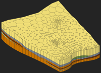
There are a number of ways to create UGrids.
UGrids can be imported by selecting the File|Open command or by dragging and dropping the file onto the GMS window. GMS recognizes the .vtu
The following data types can be converted to UGrids by right-clicking on the object in the Project Explorer and selecting the Convert To > UGrid command from the pop-up menu.
| [hide]GMS – Groundwater Modeling System | ||
|---|---|---|
| Modules: | 2D Grid • 2D Mesh • 2D Scatter Point • 3D Grid • 3D Mesh • 3D Scatter Point • Boreholes • GIS • Map • Solid • TINs • UGrids | |
| Models: | FEFLOW • FEMWATER • HydroGeoSphere • MODAEM • MODFLOW • MODPATH • mod-PATH3DU • MT3DMS • MT3D-USGS • PEST • PHT3D • RT3D • SEAM3D • SEAWAT • SEEP2D • T-PROGS • ZONEBUDGET | |
| Aquaveo | ||