AHGW:Scale XS2D Features: Difference between revisions
m (Move page script moved page AHGW:Scale XS2D Features to Test:Scale XS2D Features without leaving a redirect) |
No edit summary |
||
| Line 1: | Line 1: | ||
[[File: | [[File:ArcGIS Pro Scale XS2D Features.png|350px|thumb|right|''Scale XS2D Features'' tool in the ''Geoprocessing'' pane]] | ||
The ''Scale XS2D Features'' tool is accessed by double-clicking on "[[File: | The ''Scale XS2D Features'' tool is accessed by double-clicking on "[[File:ArcGISPro Toolbx Tool.png|16 px]] Scale XS2D Features" under the "[[File:ArcGISPro Toolset.png|16 px]] XS2D Editor" toolset under the "[[File:ArcGISPro Toolset.png|16 px]] Subsurface Analyst" toolset under the "[[File:ArcGISPro Toolbx Item.png|16 px]] ArcHydroGroundwater.pyt" toolbox. This tool scales XS2D features associated with SectionLines. All feature classes associated with the SectionID of the SectionLine being processed will be scaled using the specified vertical exaggeration. This might include feature classes such as XS2D panels, scale lines, panel dividers, and other XS2D features associated with a particular SectionLine. The tool works off of a selection set of SectionLine features; all SectionLines are processed if none are selected. | ||
:'''''ArcGIS Notes''''' – In older versions of ArcGIS, this tool is accessed through the "Arc Hydro Groundwater Tools" toolbox. The tool appears as a dialog, not a pane. | |||
The following fields are available. Required fields are marked with a [[File:ArcGIS required - green circle icon.png|8px]] icon. Fields marked with a [[File:ArcGIS | :The icons vary between ArcGIS and ArcGIS Pro. | ||
*''Input SectionLine Features'' – Click the [[File: | The following fields are available. Required fields are marked with a [[File:ArcGIS Pro Red Required Symbol.png|8 px]] icon. In ArcGIS, they are marked with a [[File:ArcGIS required - green circle icon.png|8px]] icon. Fields marked with a [[File:ArcGIS Pro Warning Red.png|12 px]] icon may not be supported or the table may not exist. | ||
*''Input XS2D_Catalog Table'' – Click the [[File: | *[[File:ArcGIS Pro Red Required Symbol.png|8 px]] ''Input SectionLine Features'' – Click the [[File:ArcGISPro Open.png|16 px]] button to bring up the ''Input SectionLine Features'' dialog in order to specify the input SectionLine features. | ||
*''New vertical scale factor for XS2D features'' – Enter the new vertical scale factor for the XS2D feature classes. XS2D features are first transformed back to 1:1 scale before this new vertical scale factor is applied. | *[[File:ArcGIS Pro Red Required Symbol.png|8 px]] ''Input XS2D_Catalog Table'' – Click the [[File:ArcGISPro Open.png|16 px]] button to bring up the ''Input XS2D_Catalog Table'' dialog in order to specify the XS2D_Catalog table, which stores feature classes associated with particular SectionLine features. | ||
*[[File:ArcGIS Pro Red Required Symbol.png|8 px]] ''New vertical scale factor for XS2D features'' – Enter the new vertical scale factor for the XS2D feature classes. XS2D features are first transformed back to 1:1 scale before this new vertical scale factor is applied. | |||
{{Navbox AHGW}} | {{Navbox AHGW}} | ||
[[Category:AHGW Subsurface Analyst]] | [[Category:AHGW Subsurface Analyst]] | ||
Latest revision as of 18:28, 14 April 2023
The Scale XS2D Features tool is accessed by double-clicking on "![]() Scale XS2D Features" under the "
Scale XS2D Features" under the "![]() XS2D Editor" toolset under the "
XS2D Editor" toolset under the "![]() Subsurface Analyst" toolset under the "
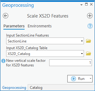
Subsurface Analyst" toolset under the "![]() ArcHydroGroundwater.pyt" toolbox. This tool scales XS2D features associated with SectionLines. All feature classes associated with the SectionID of the SectionLine being processed will be scaled using the specified vertical exaggeration. This might include feature classes such as XS2D panels, scale lines, panel dividers, and other XS2D features associated with a particular SectionLine. The tool works off of a selection set of SectionLine features; all SectionLines are processed if none are selected.
ArcHydroGroundwater.pyt" toolbox. This tool scales XS2D features associated with SectionLines. All feature classes associated with the SectionID of the SectionLine being processed will be scaled using the specified vertical exaggeration. This might include feature classes such as XS2D panels, scale lines, panel dividers, and other XS2D features associated with a particular SectionLine. The tool works off of a selection set of SectionLine features; all SectionLines are processed if none are selected.
- ArcGIS Notes – In older versions of ArcGIS, this tool is accessed through the "Arc Hydro Groundwater Tools" toolbox. The tool appears as a dialog, not a pane.
- The icons vary between ArcGIS and ArcGIS Pro.
The following fields are available. Required fields are marked with a ![]() icon. In ArcGIS, they are marked with a
icon. In ArcGIS, they are marked with a ![]() icon. Fields marked with a
icon. Fields marked with a ![]() icon may not be supported or the table may not exist.
icon may not be supported or the table may not exist.
 Input SectionLine Features – Click the
  button to bring up the Input SectionLine Features dialog in order to specify the input SectionLine features.
 Input XS2D_Catalog Table – Click the
  button to bring up the Input XS2D_Catalog Table dialog in order to specify the XS2D_Catalog table, which stores feature classes associated with particular SectionLine features.
 New vertical scale factor for XS2D features – Enter the new vertical scale factor for the XS2D feature classes. XS2D features are first transformed back to 1:1 scale before this new vertical scale factor is applied.

