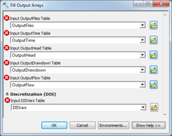
AHGW:Fill Output Arrays
From XMS Wiki
Jump to navigationJump to search
The Fill Output Arrays tool is accessed by double-clicking on "![]() Fill Output Arrays" under the "
Fill Output Arrays" under the "![]() Import" toolset under the "
Import" toolset under the "![]() MODFLOW Analyst" toolset under the "
MODFLOW Analyst" toolset under the "![]() Arc Hydro Groundwater Tools" toolbox.
Arc Hydro Groundwater Tools" toolbox.
The following fields are available. Required fields are marked with a ![]() icon. Fields marked with a
icon. Fields marked with a ![]() icon may either not be supported or the table doesn't exist.
icon may either not be supported or the table doesn't exist.
- Input OutputFiles Table – Click the
 button to bring up the Input OutputFiles Table dialog in order to specify the OutputFiles table, in MODFLOW Data Model format. This table is used to store output files (head, drawdown, ccf, etc.), or paths to these files on disk.
 - Input OutputTime Table – Click the
 button to bring up the Input OutputTime Table dialog in order to specify the OutputTime table, in MODFLOW Data Model format. This table is used to store the times at which output exists.
 - Input OutputHead Table – Click the
 button to bring up the Input OutputHead Table dialog in order to specify the OutputHead table, in MODFLOW Data Model format. This table is used to store the scalar head solution at each cell, at each output time.
 - Input OutputDrawdown Table – Click the
 button to bring up the Input OutputDrawdown Table dialog in order to specify the OutputDrawdown table, in MODFLOW Data Model format. This table is used to store the scalar drawdown solution at each cell, at each output time.
 - Input OutputFlow Table – Click the
 button to bring up the Input OutputFlow Table dialog in order to specify the OutputFlow table, in MODFLOW Data Model format. This table is used to store the scalar flow values at each cell, at each output time. These flows will be one of the following types:
- FLOW RIGHT FACE
- FLOW FRONT FACE
- FLOW LOWER FACE
- WELLS
- DRAINS
- RIVER LEAKAGE
- ET
- HEAD DEP BOUNDS
- RECHARGE
- CONSTANT HEAD
- STREAM LEAKAGE
- STORAGE
- LAKE SEEPAGE
- Discretization (DIS)
- Input DISVars Table – Click the
 button to bring up the Input DISVars Table dialog in order to specify the DISVars table, in MODFLOW Data Model format. This table contains variables associated with the DIS file.
| [show] AHGW – Arc Hydro Groundwater Toolbox |
|---|

