AHGW:Set Layer as Map Grid
From XMS Wiki
Jump to navigationJump to search
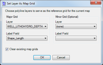
The Set Layer as Map Grid dialog is accessed by clicking ![]() Set Layer As Map Grid on the Arc Hydro Groundwater Toolbar. This tool allows polylines to serve as the reference grid for the current map in ArcGIS.
Set Layer As Map Grid on the Arc Hydro Groundwater Toolbar. This tool allows polylines to serve as the reference grid for the current map in ArcGIS.
The following sections, options, and fields are available:
- Major Grid section – Used to set the major axis for the grid.
- Layer – A drop-down populated with a list of polyline layers.
- Label Field – A drop-down populated by fields from the polyline layers that can be used to label the major grid axes.
- Minor Grid section – Optional. Used to set the minor axis for the grid
- Layer – A drop-down populated with a list of polyline layers. Default value is "(none)".
- Label Field – A drop-down populated by fields from the polyline layers that can be used to label the minor grid axes.
- Clear existing map grids – Turn on to clear any existing map grids.
- OK – Saves and changes and exits the Borehole Editor dialog.
- Cancel – Cancels any changes and exits the Borehole Editor dialog.
| [show] AHGW – Arc Hydro Groundwater Toolbox |
|---|

