SMS:Create Datasets
From XMS Wiki
(Redirected from SMS:Create Data Sets)
Jump to navigationJump to search
| This contains information about features no longer in use for the current release of SMS. The content may not apply to current versions. |
The Create Datasets dialog is obsolete as of SMS 10.1. It has been replaced by the Dataset Toolbox.
At a glance
- Automatically generate commonly used datasets
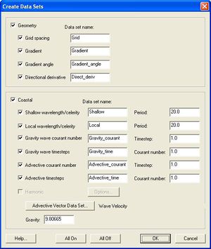
The Create Datasets dialog is used to create functions for the entire mesh or active scatter set. The option is in Data | Create Datasets in both the Scatter and Mesh modules.
Each function that is toggled on will be created. All of the available functions can be turned on by pushing All On. All of the functions can be turned off by pushing All Off. The Gravity can be set and is used in several of the function calculations. The functions that can be created include:
- Grid Spacing – Creates a function that gives the average distance between a node and its neighbors.
- Gradient – Creates a function that gives the gradient at each node. The gradient is calculated at each point by averaging the normals of the faces connected to that point. For vertices in a TIN, this includes all the triangles connected to the vertex. For nodes in a mesh, it includes all the elements connected to the node. Currently no adjustment is made to account for the varied area of these faces. The gradient is defined as the run divided by the rise.
- Gradient Angle – Creates a function that gives the direction in degrees of the maximum gradient at each point. (See above for the method used to compute the gradient.)
- Directional Derivative – Creates a vector function that gives the gradient (run/rise) in the x and y directions. (See above for the method used to compute the gradient.)
- Shallow Wavelength/Celerity – Creates two functions that calculate the celerity and wavelength at each node in shallow water. The celerity is calculated as:
- . The Wavelength is: .
- Local Wavelength/Celerity – Creates two functions that calculate the celerity and wavelength at each node for any depths.
- Gravity Wave Courant Number – Creates a function that gives the courant number for each node given the Time Step. The equation is:
- .
- Gravity Wave Time Steps – Creates a function that calculates the gravity wave time step given the Courant Number. The equation is the same as for the Gravity Wave Courant Number, solved for the Courant Number.
The final three functions can be created when the current numeric model is set to ADCIRC.
- Advective Courant Number – Creates a function that calculates the courant number given the Time Step and a velocity function. The velocity function can be selected by clicking on the Advective Functions&ldots; button. This brings up a Select Dataset dialog that lists the vector functions currently in memory. The courant cumber is calculated as:
- .
- This option is disabled if no vector functions exist.
- Advective Time Steps – Creates a function that calculates the time step given the Courant Number and a velocity function. The velocity function can be selected as described above in the description of the Advective Courant Number. The equation is the same as for the Advective Courant Number, solved for the time step. This option is disabled if no vector functions exist.
- Harmonic – Creates a scalar harmonic function and/or a vector harmonic function. Pushing the Options button brings up the Harmonic Options dialog. The name of the function(s) to be created can be set in the Name fields. The frequencies to be used in creating the function can be chosen be double-clicking on a frequency name shown in the Scalar Frequencies window or be clicking on the name and by pushing Select. A frequency can be unselected by double-clicking on the name again or by selecting it and pushing Unselect. The time values that will be used in calculating the time steps can be set in the fields at the bottom of the dialog.
Related Topics
- Mesh Module Data Menu
- Scatter Module Data Menu
- Particle Module Data Menu
- Particle Module Create Datasets
| [hide] SMS – Surface-water Modeling System | ||
|---|---|---|
| Modules: | 1D Grid • Cartesian Grid • Curvilinear Grid • GIS • Map • Mesh • Particle • Quadtree • Raster • Scatter • UGrid |  |
| General Models: | 3D Structure • FVCOM • Generic • PTM | |
| Coastal Models: | ADCIRC • BOUSS-2D • CGWAVE • CMS-Flow • CMS-Wave • GenCade • STWAVE • WAM | |
| Riverine/Estuarine Models: | AdH • HEC-RAS • HYDRO AS-2D • RMA2 • RMA4 • SRH-2D • TUFLOW • TUFLOW FV | |
| Aquaveo • SMS Tutorials • SMS Workflows | ||


