SMS:Activity Classification Coverage: Difference between revisions
No edit summary |
No edit summary |
||
| Line 1: | Line 1: | ||
[[File:ActvityClassification.png|thumb|250 px|''Activity Classification Coverage'' dialog]] | [[File:ActvityClassification.png|thumb|250 px|''Activity Classification Coverage'' dialog]] | ||
Some projects require defining which areas of the model are active or inactive. Active areas represent an elevation below the water-surface or the ocean. Inactive areas have elevations above the water-surface or are land areas. Some models automatically assign areas as active or inactive | Some projects require defining which areas of the model are active or inactive. Active areas represent an elevation below the water-surface or the ocean. Inactive areas have elevations above the water-surface or are land areas. Some models automatically assign areas as active or inactive. The Activity Classification coverage in the [[SMS:Map Module|Map module]] can be used for models that don't automatically classify activity based on elevation, or used to speed up the model run time in models that do automatically classify activity. The coverage can use all of the standard Map module [[SMS:Interface Components|interface components]]. | ||
In the coverage, polygons can be created by creating enclosed arcs and using the [[SMS:Map_Feature_Objects_Menu#General_Commands|''Feature Objects'' | '''Build Poygons''']] command. Each polygon can then be classified as active or inactive. | In the coverage, polygons can be created by creating enclosed arcs and using the [[SMS:Map_Feature_Objects_Menu#General_Commands|''Feature Objects'' | '''Build Poygons''']] command. Each polygon can then be classified as active or inactive. | ||
Revision as of 14:23, 29 March 2016
Some projects require defining which areas of the model are active or inactive. Active areas represent an elevation below the water-surface or the ocean. Inactive areas have elevations above the water-surface or are land areas. Some models automatically assign areas as active or inactive. The Activity Classification coverage in the Map module can be used for models that don't automatically classify activity based on elevation, or used to speed up the model run time in models that do automatically classify activity. The coverage can use all of the standard Map module interface components.
In the coverage, polygons can be created by creating enclosed arcs and using the Feature Objects | Build Poygons command. Each polygon can then be classified as active or inactive.
Once the active and inactive areas have been defined, the Activity Classification coverage can be linked to a simulation for use in a model run. SMS allows a project to use multiple Activity Classification coverages.
Actvity Classification Coverage Dialog
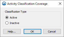
This dialog is reached by right-clicking on a polygon with the Select Feature Poylgon tool and selecting the Attributes command. The dialog that appears has the following options:
- Active – Classifies the polygon as below the surface-water elevation or as ocean.
- Inactive – Classifies the polygon as above the surface-water elevation or as land.
Related Topics
SMS – Surface-water Modeling System | ||
|---|---|---|
| Modules: | 1D Grid • Cartesian Grid • Curvilinear Grid • GIS • Map • Mesh • Particle • Quadtree • Raster • Scatter • UGrid |  |
| General Models: | 3D Structure • FVCOM • Generic • PTM | |
| Coastal Models: | ADCIRC • BOUSS-2D • CGWAVE • CMS-Flow • CMS-Wave • GenCade • STWAVE • WAM | |
| Riverine/Estuarine Models: | AdH • HEC-RAS • HYDRO AS-2D • RMA2 • RMA4 • SRH-2D • TUFLOW • TUFLOW FV | |
| Aquaveo • SMS Tutorials • SMS Workflows | ||
