SMS:Feature Object Modification: All: Difference between revisions
(→Clean) |
(→Delete) |
||
| Line 21: | Line 21: | ||
==Delete== | ==Delete== | ||
The ''Feature Objects'' | '''Delete''' command, deletes all feature objects including all coverages and entities in the coverages. A new, empty coverage is created because there must always be a coverage in SMS. This does not delete | The ''Feature Objects'' | '''Delete''' command, deletes all feature objects including all coverages and entities in the coverages. A new, empty coverage is created because there must always be a coverage in SMS. This does not delete drawing objects (annotations), DXF, or images. | ||
==Related Topics== | ==Related Topics== | ||
Revision as of 15:45, 3 May 2017
SMS provides a number of tools that facilitate modification of feature objects.
Transform Feature Objects
The Transform Feature Objects command is used to move scatter points. The user is asked which will be transformed, the active set or all sets. In the dialog that appears, the transformation type can be chosen and then appropriate parameters can be entered.
- Data can be scaled, translated, rotated
- Depths/Elevations can be converted back and forth
For more information, go to Data Transform.
Clean
The Clean command is used to fix errors in feature object data (Feature Objects menu in the Map module).
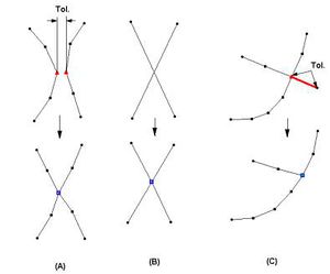
- Snap nodes – Merge any two nodes or vertices together if they are within the Tolerance of each other. The new node will be placed at the location of one of the old nodes or vertices (see Figure A).
- Snap selected nodes – Merges two or more selected nodes or vertices. Click on one of the selected points which will be treated as the new location (see Figure A).
- Intersect arcs – Places a node where two arcs intersect. All intersections are fixed with this command (see Figure B).
- Intersect selected arcs – Places a node where two arcs intersect, but only selected arcs are checked.
- Remove dangling arcs – Specify a Tolerance and all dangling arc segments (at least one end of the arc is not connected to another arc) are deleted if their length is less than the tolerance (see Figure C).
Delete
The Feature Objects | Delete command, deletes all feature objects including all coverages and entities in the coverages. A new, empty coverage is created because there must always be a coverage in SMS. This does not delete drawing objects (annotations), DXF, or images.
Related Topics
| [hide] SMS – Surface-water Modeling System | ||
|---|---|---|
| Modules: | 1D Grid • Cartesian Grid • Curvilinear Grid • GIS • Map • Mesh • Particle • Quadtree • Raster • Scatter • UGrid |  |
| General Models: | 3D Structure • FVCOM • Generic • PTM | |
| Coastal Models: | ADCIRC • BOUSS-2D • CGWAVE • CMS-Flow • CMS-Wave • GenCade • STWAVE • WAM | |
| Riverine/Estuarine Models: | AdH • HEC-RAS • HYDRO AS-2D • RMA2 • RMA4 • SRH-2D • TUFLOW • TUFLOW FV | |
| Aquaveo • SMS Tutorials • SMS Workflows | ||
