SMS:GenCade Menu: Difference between revisions
From XMS Wiki
Jump to navigationJump to search
No edit summary |
No edit summary |
||
| (One intermediate revision by the same user not shown) | |||
| Line 1: | Line 1: | ||
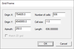
[[Image:GenCade Grid Frame. | [[Image:GenCade Grid Frame.png|thumb|250 px|''Grid Frame'' dialog opened by the '''Edit Grid''' command]] | ||
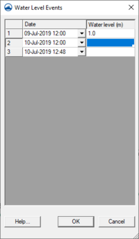
[[Image:GenCade Water Level Events. | [[Image:GenCade Water Level Events.png|thumb|200 px|''Water Level Events'' table is accessed through the '''Edit Water Level''' command]] | ||
The ''GenCade'' menu has the following commands: | The ''GenCade'' menu has the following commands: | ||
Latest revision as of 18:51, 10 July 2019
The GenCade menu has the following commands:
- Edit Grid...
- Opens a Grid Frame dialog.
- Edit Water Level...
- Opens the Water Level Events table.
- Edit Wave Data...
- Opens the Wave Gages table.
- Filter Wave Data...
- This tool was part of the GENESIS interface, but is currently not functional for GenCade.
- Edit Breakwaters...
- Opens the Detached Breakwaters table.
- Edit Seawalls...
- Opens the Seawalls table.
- Edit Groins
- Opens the Groins table.
- Edit Inlets
- Opens the Inlets (Resvoir Model and Jetties) table.
- Edit Beach Fills...
- Opens the Beach Fill table.
- Edit Bypassing...
- Opens the Bypassing table.
- Model Control...
- Starts the GenCade Model Control dialog which can be used to set beach conditions, lateral boundary conditions and general simulation options. See GenCade Model Control Dialog for more information.
- Model Check
- Starts the model checker to look for common errors.
- Run GenCade...
- This command will start the GenCade model.
Related Topics
SMS Menu Bars | |
|---|---|
| Standard Menus: | File • Edit • Display • Window • Help |
| Module Menus: | 2D Mesh • Cartesian Grid • Curvilinear Grid • GIS • Map • Particle • Quadtree • Raster • Scatter |
| Model Menus: | ADCIRC • BOUSS-2D • CGWAVE • CMS-Flow • CMS-Wave • FESWMS • Generic Model • GenCade • PTM • RMA2 • RMA4 • SRH-2D • STWAVE • TUFLOW |
SMS – Surface-water Modeling System | ||
|---|---|---|
| Modules: | 1D Grid • Cartesian Grid • Curvilinear Grid • GIS • Map • Mesh • Particle • Quadtree • Raster • Scatter • UGrid |  |
| General Models: | 3D Structure • FVCOM • Generic • PTM | |
| Coastal Models: | ADCIRC • BOUSS-2D • CGWAVE • CMS-Flow • CMS-Wave • GenCade • STWAVE • WAM | |
| Riverine/Estuarine Models: | AdH • HEC-RAS • HYDRO AS-2D • RMA2 • RMA4 • SRH-2D • TUFLOW • TUFLOW FV | |
| Aquaveo • SMS Tutorials • SMS Workflows | ||

