GMS:GIS to Feature Objects: Difference between revisions
From XMS Wiki
Jump to navigationJump to search
No edit summary |
No edit summary |
||
| Line 1: | Line 1: | ||
{{GIS links}} | {{GIS links}} | ||
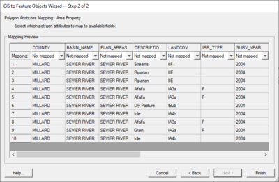
GIS vector data can be converted to [[GMS:Feature Objects|Feature Objects]] (points, arcs, polygons in coverages) for use in a [[GMS:Conceptual Model|conceptual model]]. Attributes associated with the GIS data can also be mapped over to attributes associated with Feature Objects. Two commands are available for converting GIS vector data to Feature Objects: ''''' | GIS vector data can be converted to [[GMS:Feature Objects|Feature Objects]] (points, arcs, polygons in coverages) for use in a [[GMS:Conceptual Model|conceptual model]]. Attributes associated with the GIS data can also be mapped over to attributes associated with Feature Objects. Two commands are available for converting GIS vector data to Feature Objects: ''GIS'' | '''ArcObjects → Feature Objects'''(with an ArcObjects license) and ''GIS'' | '''Shapes → Feature Objects'''. Selecting either of these commands will bring up ''GIS to Feature Objects'' wizard. | ||
Before starting the wizard, you need to make sure to set the appropriate coverage as the active coverage since the wizard will convert the GIS data to new Feature Objects in the active coverage. Also, if you are mapping over attributes, you must make sure the GMS coverage attributes are defined before you do the conversion. | Before starting the wizard, you need to make sure to set the appropriate coverage as the active coverage since the wizard will convert the GIS data to new Feature Objects in the active coverage. Also, if you are mapping over attributes, you must make sure the GMS coverage attributes are defined before you do the conversion. | ||
