GMS:Raster Catalog
| GIS Module | |
|---|---|
| GIS | |
| Enabling ArcObjects | |
| Converting GIS Data to Other Data Types | |
| GIS to Feature Objects | |
| Add Data | |
| More | |
| GIS Display Options | |
| GIS Tool Palette | |
| Images | |
| Rasters | |
| Raster Catalogs | |
| GIS Commands | |

A raster catalog is an attribute table that references rasters that are currently loaded into the GMS project. Raster catalogs are used for interpolation and to create solids from horizons.
Create a Raster Catalog
To create a raster catalog, simply select the desired rasters in the Project Explorer, right-click and select the New Raster Catalog command. A new "![]() Raster Catalog" item will then appear in the Project Explorer.
Raster Catalog" item will then appear in the Project Explorer.
The figure below shows a sample of the Raster Catalog dialog.

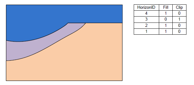
In the first column of the table selects the raster. Then enter a Horizon ID and the associated material. There are two additional fields: Fill and Clip. If the Fill field is turned on then the raster will be used in the interpolation process for the associated horizon. If the Clip field is turned on then any horizon surface with a horizon ID less than the associated horizon ID will be clipped to this surface. The following images show examples of the effect of the Clip field.
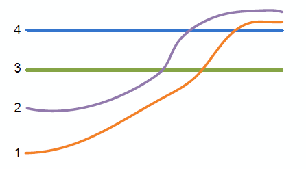 Raster surfaces.

The above figure shows a slice through raster surfaces that have been indexed with horizon IDs. Below we see the resulting stratigraphy if the Clip field is off (zero) for each raster.
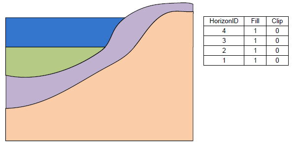 Stratigraphy with the Clip field turned off.

The next two examples show how the stratigraphy changes when the Clip field is turned on.
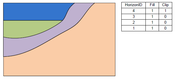 Stratigraphy with the Clip field on for horizon 4.
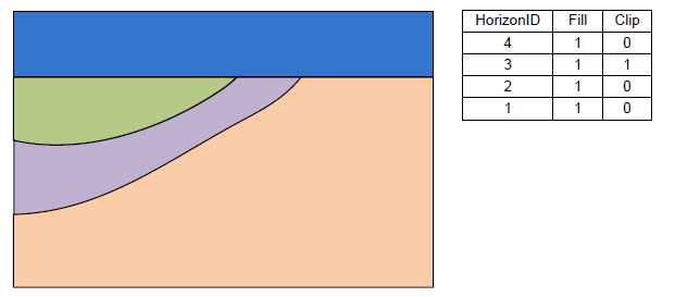 Stratigraphy with the Clip field on for horizon 3.


The final example shows a case where the Fill field is off and the Clip field is on.
 Stratigraphy with the Fill-off and Clip-on for horizon 3.

Horizons → Solids
Raster catalogs are used to create solids using the horizons to solids method. Each raster represents the top of a horizon. Right-click on the raster catalog in the Project Explorer and select the Horizons→Solids command to start the Horizons to Solids wizard.
Interpolation
A raster catalog can be interpolated to other GMS objects (TINs, meshes etc) by right-clicking on the raster catalog and selecting the desired interpolation command. Unlike interpolating from multiple selected rasters, when interpolating from a raster catalog, only one dataset will be created.
| GMS – Groundwater Modeling System | ||
|---|---|---|
| Modules: | 2D Grid • 2D Mesh • 2D Scatter Point • 3D Grid • 3D Mesh • 3D Scatter Point • Boreholes • GIS • Map • Solid • TINs • UGrids | |
| Models: | FEFLOW • FEMWATER • HydroGeoSphere • MODAEM • MODFLOW • MODPATH • mod-PATH3DU • MT3DMS • MT3D-USGS • PEST • PHT3D • RT3D • SEAM3D • SEAWAT • SEEP2D • T-PROGS • ZONEBUDGET | |
| Aquaveo | ||