SMS:Refine Point Dialog: Difference between revisions
No edit summary |
No edit summary |
||
| (3 intermediate revisions by 2 users not shown) | |||
| Line 1: | Line 1: | ||
[[Image:Refine Point2. | [[Image:Refine Point2.png|thumb|225 px|The standard ''Refine Point'' dialog]] | ||
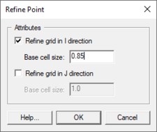
The ''Refine Point'' dialog is used to set the attributes for a refine point represented by a [[SMS:Feature Objects Types|feature point]] in a Cartesian | The ''Refine Point'' dialog is used to set the attributes for a refine point represented by a [[SMS:Feature Objects Types|feature point]] in a Cartesian grid model coverage. Refine points for a Cartesian Grid allow changing the cell dimensions when generating the grid. The dialog is reached by selecting a point in a Cartesian grid coverage and selecting the ''Feature Objects'' | '''Attributes''' command. | ||
Attributes that can be specified for each refine point include: | Attributes that can be specified for each refine point include: | ||
* ''Refine grid in I direction'' – Has the following option when turn on: | * ''Refine grid in I direction'' – Has the following option when turn on: | ||
** ''Base cell size'' – Specify the cell I size in the vicinity of the refine point. | |||
* ''Base cell size'' – Specify the cell I size in the vicinity of the refine point. | ** ''Refine grid in J direction'' – Has the following option when turned on: | ||
* ''Refine grid in J direction'' – Has the following option when turned on: | * ''Base cell size'' – Specify the cell J size in the vicinity of the refine point. | ||
* ''Base cell size'' – Specify the cell J size in the vicinity of the refine point. | |||
Only refine points located within a [[SMS:Grid Frame Properties|grid frame]] are used when the [[SMS:Converting Feature Objects#Map to 2D Grid|'''Map → 2D Grid''']] command is executed. Refine points are not available for all models, since some Cartesian | Only refine points located within a [[SMS:Grid Frame Properties|grid frame]] are used when the [[SMS:Converting Feature Objects#Map to 2D Grid|'''Map → 2D Grid''']] command is executed. Refine points are not available for all models, since some Cartesian grid models require uniform cell sizes. When the refining is performed, the base size may be changed in order to fit the other restrictions applied to the refining process. If two refine points are too close to each other to allow the cell size to transition, one will be ignored when generating the grid | ||
1D Grid models can also make use of a refine point. For information on this, see [[SMS:GenCade_Graphical_Interface#Feature_Points|GenCade]]. | 1D Grid models can also make use of a refine point. For information on this, see [[SMS:GenCade_Graphical_Interface#Feature_Points|GenCade]]. | ||
Latest revision as of 20:50, 17 October 2019
The Refine Point dialog is used to set the attributes for a refine point represented by a feature point in a Cartesian grid model coverage. Refine points for a Cartesian Grid allow changing the cell dimensions when generating the grid. The dialog is reached by selecting a point in a Cartesian grid coverage and selecting the Feature Objects | Attributes command.
Attributes that can be specified for each refine point include:
- Refine grid in I direction – Has the following option when turn on:
- Base cell size – Specify the cell I size in the vicinity of the refine point.
- Refine grid in J direction – Has the following option when turned on:
- Base cell size – Specify the cell J size in the vicinity of the refine point.
Only refine points located within a grid frame are used when the Map → 2D Grid command is executed. Refine points are not available for all models, since some Cartesian grid models require uniform cell sizes. When the refining is performed, the base size may be changed in order to fit the other restrictions applied to the refining process. If two refine points are too close to each other to allow the cell size to transition, one will be ignored when generating the grid
1D Grid models can also make use of a refine point. For information on this, see GenCade.
Related Topics
SMS – Surface-water Modeling System | ||
|---|---|---|
| Modules: | 1D Grid • Cartesian Grid • Curvilinear Grid • GIS • Map • Mesh • Particle • Quadtree • Raster • Scatter • UGrid |  |
| General Models: | 3D Structure • FVCOM • Generic • PTM | |
| Coastal Models: | ADCIRC • BOUSS-2D • CGWAVE • CMS-Flow • CMS-Wave • GenCade • STWAVE • WAM | |
| Riverine/Estuarine Models: | AdH • HEC-RAS • HYDRO AS-2D • RMA2 • RMA4 • SRH-2D • TUFLOW • TUFLOW FV | |
| Aquaveo • SMS Tutorials • SMS Workflows | ||
