SMS:Mapping Coverage: Difference between revisions
From XMS Wiki
Jump to navigationJump to search
No edit summary |
No edit summary |
||
| Line 1: | Line 1: | ||
==Mapping Options== | |||
When creating a new Mapping coverage from the ''New Coverages'' dialog, the ''Mapping Options'' dialog will appear. | |||
==Mapping Arc Attributes Dialog== | ==Mapping Arc Attributes Dialog== | ||
[[Image:Mapping Arc Att.jpg|thumb|225 px|''Arc Attributes'' dialog]] | [[Image:Mapping Arc Att.jpg|thumb|225 px|''Arc Attributes'' dialog]] | ||
Revision as of 15:56, 19 June 2015
Mapping Options
When creating a new Mapping coverage from the New Coverages dialog, the Mapping Options dialog will appear.
Mapping Arc Attributes Dialog
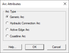
The Arc Attributes dialog is used to set the attributes for feature arcs in a Mapping type coverage. Attributes that can be specified for each arc include:
- Generic Arc
- Hydraulic Connection Arc
- Active Edge Arc
- Coastline Arc
The dialog is reached by double-clicking on an arc with the Select Feature Arc tool with the Mapping type coverage active.
Mapping Polygon Attributes Dialog
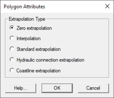
The Polygon Attributes dialog is used to set the attributes for feature polygons in a Mapping type coverage. Attributes that can be specified for each polygon include:
- Extrapolation Type
- Zero extrapolation
- Interpolation
- Standard extrapolation
- Hydraulic connection extrapolation
- Coastline extrapolation
The dialog is reached by double-clicking on a polygon with the Select Feature Poygon tool with the Mapping type coverage active.
Related Topics
SMS – Surface-water Modeling System | ||
|---|---|---|
| Modules: | 1D Grid • Cartesian Grid • Curvilinear Grid • GIS • Map • Mesh • Particle • Quadtree • Raster • Scatter • UGrid |  |
| General Models: | 3D Structure • FVCOM • Generic • PTM | |
| Coastal Models: | ADCIRC • BOUSS-2D • CGWAVE • CMS-Flow • CMS-Wave • GenCade • STWAVE • WAM | |
| Riverine/Estuarine Models: | AdH • HEC-RAS • HYDRO AS-2D • RMA2 • RMA4 • SRH-2D • TUFLOW • TUFLOW FV | |
| Aquaveo • SMS Tutorials • SMS Workflows | ||

