SMS:Mesh Generation
At a glance
- Generating a quality finite element mesh is central to using many SMS models
- Conceptual models make generating meshes easier
- Polygons can use a variety of meshing options to generate triangular or quadrilateral elements
- Polygons can be assigned bathymetry and material information that will be transferred with the mesh
- Constant paving density and Scalar paving density generates elements with sizes based upon a size dataset allowing for smooth transitions and a large range of element sizes and is particularly useful for coastal and wave models.
- For the constant option, the element target size is specified for each polygon.
- For the spatially varying (scalar paving) option, the target element size is based upon a size dataset on a TIN allowing for smooth transitions and a large range of element sizes.
- Datasets for scalar paving density can be user defined or generated using the Data Calculator, the Dataset Toolbox, or LTEA (linear truncation error analysis) (ADCIRC)
2D Meshes are created in the following ways in SMS.
Using a Conceptual Model
This method converts a conceptual model to a mesh using the Map → 2D Mesh command. This is the preferred method for mesh generation in SMS.
The mesh generation capability is based on feature objects.
- Mesh From Coverage
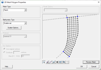
- Each polygon in a meshing coverage (such as mesh generator, ADCIRC or CGWAVE) includes a mesh type attribute. This attribute defines how SMS should generate nodes inside the polygon and connect them into elements. Individual polygons in the coverage may each utilize their own meshing type. SMS supports the following principal mesh type attributes:
- Mesh Generation Toolbox
- The mesh generation toolbox is the first pass at a new approach to further automating the mesh generation process. Currently the toolbox includes a single option to generate ADCIRC meshes with automatic density variation. This tool is based on Local Truncation Error Analysis.
Mesh Generator Coverage
Starting in SMS 12.0, a generic Mesh Generator coverage can be created. This coverage replaces previous coverages for creating a mesh from the Map module.
Manually Creating a 2D Mesh
In order to create a 2D Mesh in SMS, there must be a set of 2D Mesh nodes. Elements can be created by using one of the create mesh element tools and then selecting the mesh nodes to create elements. A 2D Mesh can also be created by triangulating the nodes. The triangulation algorithm assumes that each of the vertices being triangulated is unique in the xy plane, i.e. no two points have the same xy location. Duplicate points can be removed by selecting Select/Delete Duplicate Nodes command from the Node menu.
A 2D Mesh can be created manually from the following steps:
- Select the Create Nodes tool from the Tool Palette.
- Create the nodes by clicking inside the Graphics Window at the xy coordinates where the vertex are to be located. (To change the node location see Editing Node Coordinates)
- Select a Create Element tool from the Tool Palette OR Select the Elements | Triangulate command from the Mesh menu to form triangular elements using a Delaunay triangulation.
Creating a 2D Mesh from Existing Geometry
TINs, 2D grids, 2D scatter points, and 3D meshes (in GMS) can all be converted to a 2D Mesh. This is accomplished by using the following commands:
- TIN → 2D Mesh
- 2D Grid → 2D Mesh
- 2D Scatter Points → 2D Mesh Nodes
- 3D Mesh → 2D Mesh
After using the Scatter Points → Mesh Nodes command, triangulate the nodes to create the 2D Mesh.
A finite element mesh is defined as a network of triangular and quadrilateral elements constructed from nodes. SMS includes advanced tools to create finite element meshes from underlying bathymetry, meshing parameters and mesh domain limits.
Digitized or survey points can be imported to provide the bathymetry. This type of data is generally not appropriate for use as mesh nodes due to random location and distribution. In this case the data should be converted to scatter points. If the bathymetric points are to be directly used as nodes, the triangulate command can generate elements from the points.
The Map Module provides tools for defining the study area boundaries and features from which a finite element mesh can be created. SMS then interpolates the bathymetry data onto the mesh. This process is also described in Lesson 2 of the tutorials. The Mesh Module provides various Tools for manually editing the finite element mesh.
Related Links
- Mesh Module
- Scatter Data Interpolation
- Adaptive Tesselation
- Advancing Front Triangulation
- Patches
- Refine Points
SMS – Surface-water Modeling System | ||
|---|---|---|
| Modules: | 1D Grid • Cartesian Grid • Curvilinear Grid • GIS • Map • Mesh • Particle • Quadtree • Raster • Scatter • UGrid |  |
| General Models: | 3D Structure • FVCOM • Generic • PTM | |
| Coastal Models: | ADCIRC • BOUSS-2D • CGWAVE • CMS-Flow • CMS-Wave • GenCade • STWAVE • WAM | |
| Riverine/Estuarine Models: | AdH • HEC-RAS • HYDRO AS-2D • RMA2 • RMA4 • SRH-2D • TUFLOW • TUFLOW FV | |
| Aquaveo • SMS Tutorials • SMS Workflows | ||
