GMS:MODPATH Particle Sets
| MODPATH | |
|---|---|
| Pre-processing | |
| MODPATH Commands | |
| MODPATH Particle Tracking | |
| MODPATH Particle Sets | |
| MODPATH Zone Codes | |
| Post-processing | |
| MODPATH Display Options | |
| Exporting Pathlines | |
| Tutorials | |
| MODPATH Tutorials | |
MODPATH particles are grouped into sets. For each set, the user can specify the name of the set, the tracking direction, the tracking duration, and if the particles in the set should be displayed.
Grouping particles into sets increases the power and flexibility of particle tracking. For example, several particle sets, some tracking backward and some forward can all be displayed at once. Or, several particle sets, each with different tracking times, can all be displayed at the same time. This can be used to show nested capture zones.
Active Particle Set
One particle set is always designated as the active particle set, and there is never more than one active particle set. Whenever particles are created, they are added to the active particle set. Particles can only be deleted from the active particle set—to delete particles in a particle set that is not active, it's necessary first make it active.
Order
The order that particle sets are listed in the Data Tree corresponds to the order they are displayed. Thus, particle sets that are listed at the top are displayed on top of particle sets listed further down. The order can be changed by dragging the particle sets.
Creation / Deletion
If a particle set is deleted, all the particles in the set are deleted.
If there are no particle sets, and when the user creates particles, a particle set is automatically created.
Pathline Export
See Exporting Pathlines.
Spreadsheet Report
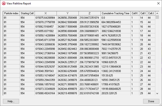
In addition to the text file export, there is an option for generating a tabular report directly within GMS. This report is accessed by right-clicking on a particle set in the Project Explorer and selecting the View Pathline Report command. This command brings up the following dialog:
| GMS – Groundwater Modeling System | ||
|---|---|---|
| Modules: | 2D Grid • 2D Mesh • 2D Scatter Point • 3D Grid • 3D Mesh • 3D Scatter Point • Boreholes • GIS • Map • Solid • TINs • UGrids | |
| Models: | FEFLOW • FEMWATER • HydroGeoSphere • MODAEM • MODFLOW • MODPATH • mod-PATH3DU • MT3DMS • MT3D-USGS • PEST • PHT3D • RT3D • SEAM3D • SEAWAT • SEEP2D • T-PROGS • ZONEBUDGET | |
| Aquaveo | ||
