WMS:HEC-HMS Gages: Difference between revisions
No edit summary |
No edit summary |
||
| (20 intermediate revisions by the same user not shown) | |||
| Line 1: | Line 1: | ||
The User Gage Weighting method allows | The User Gage Weighting method allows defining one or more gages for each sub-basin in the watershed model. | ||
The method of defining gages in HMS is similar to the method of defining gages in HEC-1. For each basin, | The method of defining gages in HMS is similar to the method of defining gages in HEC-1. For each basin, define one or more total storm gages and one recording gage. WMS has the capability to automatically determine gage weights for each sub-basin using the Thiessen polygon method. The data required for the "User Gage Weighting" method are shown below: | ||
[[Image:HMS_Gages1.jpg|thumb|none|left|500 px|''HMS Meteorological Model'' dialog]] | :[[Image:HMS_Gages1.jpg|thumb|none|left|500 px|''HMS Meteorological Model'' dialog for the "User Gage Weighting" method.]] | ||
If | If there is a Map or DEM-based watershed associated with a coordinate system, import [http://dipper.nws.noaa.gov/hdsb/data/nexrad/nexrad.html NEXRAD RADAR grids in XMRG format] and WMS will convert the radar data to gages in a [[WMS:Rain_Gage|rain gage coverage]] in the current [[Coordinate_Systems|coordinate system]]. The RADAR grids are read by selecting the [[WMS:HEC-HMS Convert Grids|'''Radar Data→Rain Gages''']] button and defining the grids and the time step associated with the grids. | ||
Here is how | Here is how to define meteorological data for each sub-basin using the user gage weighting method: | ||
# Select the '''Define''' button under the total storm gages column. The following ''HMS Gage Weights'' dialog will appear: <br> [[Image:HMS_Gages2.jpg|thumb|none|left|225 px|''HMS Gage Weights'' dialog]] | |||
# Define any rain gage data that exists by selecting the '''Gages''' button. The ''Rain Gage Properties'' dialog will appear. Enter gage data for any storm total stations (total storm precipitation values) and at least one temporal distribution station (XY series of precipitation values for the entire storm). [[Image:HMS_Gages3.jpg|thumb|none|left|440 px|''HEC-1 Gages'' dialog]] | |||
[[Image:HMS_Gages2.jpg|thumb|none|left|225 px|''HMS Gage Weights'' dialog]] | # After done defining all the gage data, go back to the ''HMS Gage Weights'' dialog and add one or more gage weights associated with a total storm gage station. Enter the weights for each of these gages, as shown below. <br>[[Image:HMS_Gages4.jpg|thumb|none|left|225 px|''HMS Gage Weights'' dialog]] | ||
# Go back to the ''HMS Meteorological Model'' dialog, select the '''Define''' button under ''Recording Gages'', and define one recording gage for the basin. This is a gage which defines the temporal distribution of the rainfall. Normally, define only a single recording gage, though it is possible to define more than one. <br>[[Image:HMS_Gages5.jpg|thumb|none|left|225 px|''HMS Gage Weights'' dialog]] | |||
# Go back to the ''HMS Meteorological Model'' dialog and (optionally) enter index precipitation values for each sub-basin. This index precipitation accounts for regional precipitation variation between sub-basins. | |||
[[Image:HMS_Gages3.jpg|thumb|none|left| | |||
[[Image:HMS_Gages4. | |||
[[Image:HMS_Gages5. | |||
== Related Topics: == | == Related Topics: == | ||
| Line 34: | Line 22: | ||
{{Template:WMSMain}} | {{Template:WMSMain}} | ||
[[Category:HEC-HMS|G]] | |||
[[Category:Gages|H]] | |||
[[Category:HEC-HMS Dialogs|G]] | |||
[[Category:External Links]] | |||
[[Category:Needs Update]] <!--WMS doesn't seem to follow this anymore.--> | |||
Latest revision as of 16:23, 11 October 2017
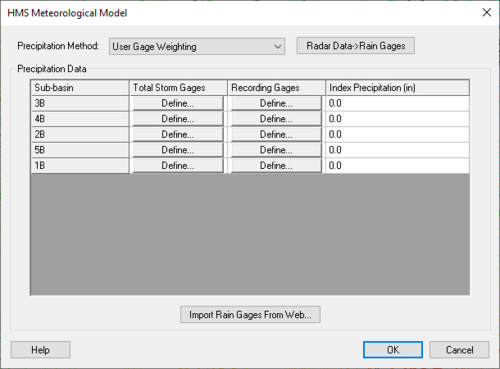
The User Gage Weighting method allows defining one or more gages for each sub-basin in the watershed model.
The method of defining gages in HMS is similar to the method of defining gages in HEC-1. For each basin, define one or more total storm gages and one recording gage. WMS has the capability to automatically determine gage weights for each sub-basin using the Thiessen polygon method. The data required for the "User Gage Weighting" method are shown below:
If there is a Map or DEM-based watershed associated with a coordinate system, import NEXRAD RADAR grids in XMRG format and WMS will convert the radar data to gages in a rain gage coverage in the current coordinate system. The RADAR grids are read by selecting the Radar Data→Rain Gages button and defining the grids and the time step associated with the grids.
Here is how to define meteorological data for each sub-basin using the user gage weighting method:
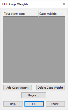
- Select the Define button under the total storm gages column. The following HMS Gage Weights dialog will appear:
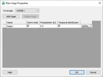
- Define any rain gage data that exists by selecting the Gages button. The Rain Gage Properties dialog will appear. Enter gage data for any storm total stations (total storm precipitation values) and at least one temporal distribution station (XY series of precipitation values for the entire storm).
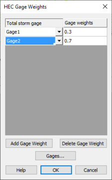
- After done defining all the gage data, go back to the HMS Gage Weights dialog and add one or more gage weights associated with a total storm gage station. Enter the weights for each of these gages, as shown below.
- Go back to the HMS Meteorological Model dialog, select the Define button under Recording Gages, and define one recording gage for the basin. This is a gage which defines the temporal distribution of the rainfall. Normally, define only a single recording gage, though it is possible to define more than one.
- Go back to the HMS Meteorological Model dialog and (optionally) enter index precipitation values for each sub-basin. This index precipitation accounts for regional precipitation variation between sub-basins.
Related Topics:
WMS – Watershed Modeling System | ||
|---|---|---|
| Modules: | Terrain Data • Drainage • Map • Hydrologic Modeling • River • GIS • 2D Grid • 2D Scatter |  |
| Models: | CE-QUAL-W2 • GSSHA • HEC-1 • HEC-HMS • HEC-RAS • HSPF • MODRAT • NSS • OC Hydrograph • OC Rational • Rational • River Tools • Storm Drain • SMPDBK • SWMM • TR-20 • TR-55 | |
| Toolbars: | Modules • Macros • Units • Digitize • Static Tools • Dynamic Tools • Drawing • Get Data Tools | |
| Aquaveo | ||


