WMS:What's new in WMS version 11.2: Difference between revisions
From XMS Wiki
Jump to navigationJump to search
| (5 intermediate revisions by 2 users not shown) | |||
| Line 9: | Line 9: | ||
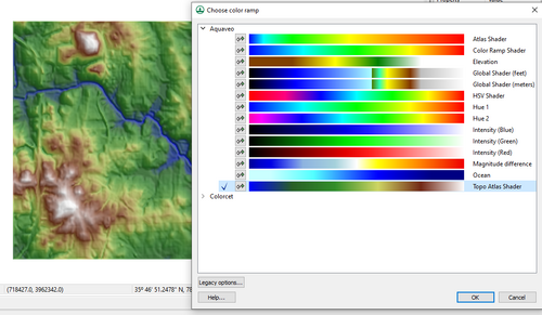
:[[File:ColorPalettes.png|thumb|none|500 px|New color palette dialog]] | :[[File:ColorPalettes.png|thumb|none|500 px|New color palette dialog]] | ||
* Film loop animations can now exported as MP4 files. This allows you to view film loop animations in a wide range of applications that support MP4 files instead of being limited to the "pavia" application bundled with WMS that supports old-style AVI files. | * Film loop animations can now exported as MP4 files. This allows you to view film loop animations in a wide range of applications that support MP4 files instead of being limited to the "pavia" application bundled with WMS that supports old-style AVI files. | ||
*Improved advanced web services support to include additional data sources. New data sources includes support for [https://www.usgs.gov/3d-elevation-program 3DEP data]. | |||
===TR-20=== | ===TR-20=== | ||
* The WinTR-20 model is now included with the TR-20 interface in WMS. WMS allows | * The WinTR-20 model is now included with the TR-20 interface in WMS. WMS allows saving and running WinTR-20 models then reading the results of WinTR-20 models that have been run. This model is an updated version of the TR-20 model that is used in both the WinTR-20 and WinTR-55 programs. There are slight differences in data requirements between WinTR-20 and TR-20, but the same interface was used with some modifications to some of the interface dialogs. For example, WinTR-20 channel cross sections require a top width for each cross section elevation as well as an energy grade slope. These parameters are not required when building an old-style TR-20 model but are included in the TR-20 dialogs to allow you to develop WinTR-20 models. | ||
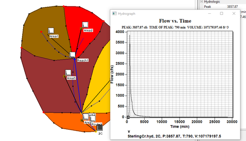
:[[File:WinTR20.png|thumb|none|500 px|WinTR-20 model setup in WMS]] | :[[File:WinTR20.png|thumb|none|500 px|WinTR-20 model setup in WMS]] | ||
=== | ===Toolbox=== | ||
* The | * The new Toolbox (beta version) has been added to WMS. This toolbox includes several tools that allow WMS users to perform a wide range of geometric and raster calculations on Map module (coverage) data, LIDAR data, and Raster (image) data. <!-- The tools are written using scripts written in the Python programming language and are intended to introduce Python scripting capabilities into WMS. Future versions of WMS will allow user-defined custom tools to be developed using similar Python scripts. Though the tools are fairly stable, they are continuously evolving and this toolbox is marked as a "Beta" feature of WMS.--> | ||
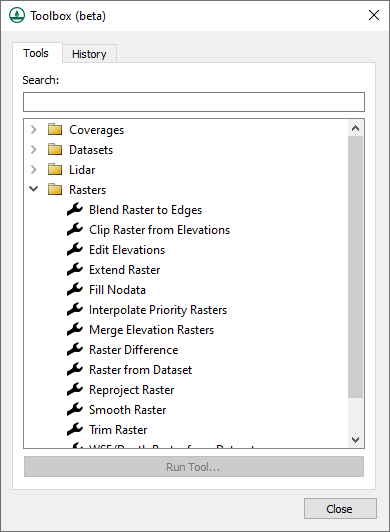
:[[File:PythonToolboxWMS.png|thumb|none|500 px|Python toolbox dialog in WMS]] | |||
== Release Notes == | == Release Notes == | ||
Latest revision as of 16:16, 30 May 2023
| This contains information about functionality available starting at WMS version 11.2. The content may not apply to other versions. |
The WMS software development team is excited about the release of WMS 11.2! This page lists the exciting new features that have been added to WMS 11.2.
What's new in WMS 11.2
General
- WMS 11.2 includes a new color palette dialog that includes several new palettes and supports all the existing palettes that have been supported in the past. This new dialog allows users to quickly view and select a palette, reverse the colors in a palette, and mark palettes as favorites.
- Film loop animations can now exported as MP4 files. This allows you to view film loop animations in a wide range of applications that support MP4 files instead of being limited to the "pavia" application bundled with WMS that supports old-style AVI files.
- Improved advanced web services support to include additional data sources. New data sources includes support for 3DEP data.
TR-20
- The WinTR-20 model is now included with the TR-20 interface in WMS. WMS allows saving and running WinTR-20 models then reading the results of WinTR-20 models that have been run. This model is an updated version of the TR-20 model that is used in both the WinTR-20 and WinTR-55 programs. There are slight differences in data requirements between WinTR-20 and TR-20, but the same interface was used with some modifications to some of the interface dialogs. For example, WinTR-20 channel cross sections require a top width for each cross section elevation as well as an energy grade slope. These parameters are not required when building an old-style TR-20 model but are included in the TR-20 dialogs to allow you to develop WinTR-20 models.
Toolbox
- The new Toolbox (beta version) has been added to WMS. This toolbox includes several tools that allow WMS users to perform a wide range of geometric and raster calculations on Map module (coverage) data, LIDAR data, and Raster (image) data.
Release Notes
Visit the WMS release notes page to view the list of bugs fixed.
WMS – Watershed Modeling System | ||
|---|---|---|
| Modules: | Terrain Data • Drainage • Map • Hydrologic Modeling • River • GIS • 2D Grid • 2D Scatter |  |
| Models: | CE-QUAL-W2 • GSSHA • HEC-1 • HEC-HMS • HEC-RAS • HSPF • MODRAT • NSS • OC Hydrograph • OC Rational • Rational • River Tools • Storm Drain • SMPDBK • SWMM • TR-20 • TR-55 | |
| Toolbars: | Modules • Macros • Units • Digitize • Static Tools • Dynamic Tools • Drawing • Get Data Tools | |
| Aquaveo | ||


