WMS:MWBM Erosion/Deposition Maps: Difference between revisions
From XMS Wiki
Jump to navigationJump to search
No edit summary |
No edit summary |
||
| Line 15: | Line 15: | ||
{{WMSMWBMModWizard}} | {{WMSMWBMModWizard}} | ||
{{WMSMain}} | {{WMSMain}} | ||
[[Category:WMS Dialogs]] | |||
[[Category:MWBM]] | |||
Revision as of 20:00, 14 November 2014
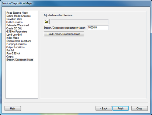
The Erosion/Deposition step is used to generate maps of erosion and deposition.
Help
Adjusted elevation filename – Select the the adjusted elevation filename generated by GSSHA.
Erosion/Deposition exaggeration factor – This variable is used to multiply the elevation changes due to erosion and deposition.
Build Erosion/Deposition Maps – This button will begin the process of generating the erosion and deposition maps. First, it will determine the amount of elevation change. It will then exaggerate it. It is the classified according to erosion, deposition, and little change.
MWBM Wizard
WMS – Watershed Modeling System | ||
|---|---|---|
| Modules: | Terrain Data • Drainage • Map • Hydrologic Modeling • River • GIS • 2D Grid • 2D Scatter |  |
| Models: | CE-QUAL-W2 • GSSHA • HEC-1 • HEC-HMS • HEC-RAS • HSPF • MODRAT • NSS • OC Hydrograph • OC Rational • Rational • River Tools • Storm Drain • SMPDBK • SWMM • TR-20 • TR-55 | |
| Toolbars: | Modules • Macros • Units • Digitize • Static Tools • Dynamic Tools • Drawing • Get Data Tools | |
| Aquaveo | ||
