WMS:HEC-HMS Properties: Difference between revisions
No edit summary |
(add info from a tutorial which fits better here) |
||
| Line 13: | Line 13: | ||
[[Image:HMS Properties2.jpg|thumb|none|left|520 px|''HMS Properties'' dialog]] | [[Image:HMS Properties2.jpg|thumb|none|left|520 px|''HMS Properties'' dialog]] | ||
The HMS documentation can be reviewed for detailed model formulation and behavior of the various properties, but different functions of the dialog are | Displaying and showing options allows users to see only those variables for which they wish to enter data. Toggling on ''Loss Rate Method'' in the ''Display'' column allows users to pick which method they want to use. Then toggle the display for the different parameters associated with a given methodology from the ''Show'' column. | ||
The ''HMS Properties'' window is versatile in that it allows users to see properties for all or selected basins, junctions, reaches, reservoirs, etc. The HMS documentation can be reviewed for detailed model formulation and behavior of the various properties, but different functions of the dialog are defined below: | |||
'''Type''' – Specifies which type of hydrologic unit parameters to view or edit. | '''Type''' – Specifies which type of hydrologic unit parameters to view or edit. | ||
Revision as of 23:16, 8 October 2015
HMS includes the following hydrologic units which can be used to define a model:
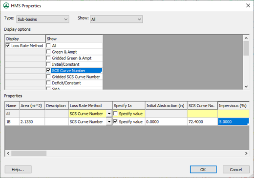
All of the parameters (properties) are edited from the same HMS Properties dialog shown below.
Displaying and showing options allows users to see only those variables for which they wish to enter data. Toggling on Loss Rate Method in the Display column allows users to pick which method they want to use. Then toggle the display for the different parameters associated with a given methodology from the Show column.
The HMS Properties window is versatile in that it allows users to see properties for all or selected basins, junctions, reaches, reservoirs, etc. The HMS documentation can be reviewed for detailed model formulation and behavior of the various properties, but different functions of the dialog are defined below:
Type – Specifies which type of hydrologic unit parameters to view or edit.
Show – Choose to show or edit the parameters of the selected or all hydrologic units of the specified type.
Display Options – The display options determine which properties (Display column) and which methods (Show column) are displayed/edited in the Properties spreadsheet.
Properties – The properties of the selected (or all) hydrologic units are displayed as a spreadsheet for editing in this area. Only the properties and methods as determined in the display options are visible for review and editing. While more than one method may have properties displayed, a method for simulation must be chosen as one of the properties.
Related Topics
WMS – Watershed Modeling System | ||
|---|---|---|
| Modules: | Terrain Data • Drainage • Map • Hydrologic Modeling • River • GIS • 2D Grid • 2D Scatter |  |
| Models: | CE-QUAL-W2 • GSSHA • HEC-1 • HEC-HMS • HEC-RAS • HSPF • MODRAT • NSS • OC Hydrograph • OC Rational • Rational • River Tools • Storm Drain • SMPDBK • SWMM • TR-20 • TR-55 | |
| Toolbars: | Modules • Macros • Units • Digitize • Static Tools • Dynamic Tools • Drawing • Get Data Tools | |
| Aquaveo | ||
