SMS:Area Property Coverage: Difference between revisions
No edit summary |
|||
| (3 intermediate revisions by the same user not shown) | |||
| Line 8: | Line 8: | ||
==Area Property Polygon Attributes Dialog== | ==Area Property Polygon Attributes Dialog== | ||
[[File:Land Polygon Attributes. | [[File:Land Polygon Attributes.png|thumb|225 px|''Land Polygon Attributes'' dialog]] | ||
The ''Land Polygon Attributes'' dialog is used to set the attributes for [[SMS:Feature Objects Types|feature polygons]]. It is reached by double-clicking on a polygon in an Area Properties coverage. Attributes that can be specified for each polygon include: | The ''Land Polygon Attributes'' dialog is used to set the attributes for [[SMS:Feature Objects Types|feature polygons]]. It is reached by double-clicking on a polygon in an Area Properties coverage. Attributes that can be specified for each polygon include: | ||
* Polygon Type | * Polygon Type | ||
| Line 14: | Line 14: | ||
* ''None '' – No attributes are assigned to the polygon. | * ''None '' – No attributes are assigned to the polygon. | ||
* ''Material'' – With this option selected, a material can be assigned to the polygon from the drop-down list below. Only materials defined in the ''Materials Data'' dialog before they can be assigned to a polygon. | * ''Material'' – With this option selected, a material can be assigned to the polygon from the drop-down list below. Only materials defined in the ''Materials Data'' dialog before they can be assigned to a polygon. | ||
</blockquote> | </blockquote> | ||
| Line 27: | Line 25: | ||
[[Category:SMS Map|Area Property Coverage]] | [[Category:SMS Map|Area Property Coverage]] | ||
[[Category:SMS Coverages| | [[Category:SMS Coverages|Area]] | ||
[[Category:SMS Map Dialogs]] | [[Category:SMS Map Dialogs|Area]] | ||
Latest revision as of 15:07, 11 September 2019
An area property coverage is used to map properties such as Manning's roughness values to the mesh, grid, or cross-sections.
Materials are used to define different values for the property the material represents. For example, if the material represents the Manning's roughness value, materials are defined to represent the different Manning's roughness values to be included in the model (stream, floodplain, field, roadway, etc.). Polygons can then be created to define the stream, floodplain, field, and roadway with the corresponding material assigned.
Materials are assigned a name, color and pattern for display, and model specific attributes.
Many of the data entities constructed and edited in SMS (i.e., elements, cells) have a material ID associated with them. This material ID is an index into a list of material types. Materials contain model specific parameters such as manning's roughness, or bed material grain size. A global list of material attributes is maintained and can be edited using the menu command Edit | Materials Data. This command brings up the Materials Data dialog where each material is assigned an ID number. This dialog can be used to delete unused materials, create new materials, and assign a descriptive name, color, and pattern to a material. This general information is saved in the material file. The materials defined within the Materials Data dialog are available for all modules.
Area Property Polygon Attributes Dialog
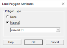
The Land Polygon Attributes dialog is used to set the attributes for feature polygons. It is reached by double-clicking on a polygon in an Area Properties coverage. Attributes that can be specified for each polygon include:
- Polygon Type
- None – No attributes are assigned to the polygon.
- Material – With this option selected, a material can be assigned to the polygon from the drop-down list below. Only materials defined in the Materials Data dialog before they can be assigned to a polygon.
Related Topics
SMS – Surface-water Modeling System | ||
|---|---|---|
| Modules: | 1D Grid • Cartesian Grid • Curvilinear Grid • GIS • Map • Mesh • Particle • Quadtree • Raster • Scatter • UGrid |  |
| General Models: | 3D Structure • FVCOM • Generic • PTM | |
| Coastal Models: | ADCIRC • BOUSS-2D • CGWAVE • CMS-Flow • CMS-Wave • GenCade • STWAVE • WAM | |
| Riverine/Estuarine Models: | AdH • HEC-RAS • HYDRO AS-2D • RMA2 • RMA4 • SRH-2D • TUFLOW • TUFLOW FV | |
| Aquaveo • SMS Tutorials • SMS Workflows | ||
