SMS:Select/Delete Data...: Difference between revisions
From XMS Wiki
Jump to navigationJump to search
No edit summary |
No edit summary |
||
| (2 intermediate revisions by the same user not shown) | |||
| Line 1: | Line 1: | ||
__NOINDEX__ | |||
{{SMS Deprecated Feature}} | |||
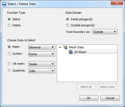
[[Image:SMS Select Delete Data.png|thumb|400 px|''Select/Delete Data'' dialog]] | [[Image:SMS Select Delete Data.png|thumb|400 px|''Select/Delete Data'' dialog]] | ||
The''' Select/Delete Data...''' command ([[SMS:Map_Feature_Objects_Menu#General_Commands|''Feature Objects'']] menu, Map module) is available when one or more polygons are selected. Select or delete data that is located inside or outside of selected polygons. Options are provided to select or delete mesh node, elements or duplicate nodes, scatter points or triangle, Cartesian grid cells or cell location that are partially (triangles/elements that cross a boundary) or completely inside/outside the polygons. | The''' Select/Delete Data...''' command ([[SMS:Map_Feature_Objects_Menu#General_Commands|''Feature Objects'']] menu, Map module) is available when one or more polygons are selected. Select or delete data that is located inside or outside of selected polygons. Options are provided to select or delete mesh node, elements or duplicate nodes, scatter points or triangle, Cartesian grid cells or cell location that are partially (triangles/elements that cross a boundary) or completely inside/outside the polygons. | ||
| Line 12: | Line 14: | ||
*''Choose Data to Select'' – Choose the data type to select or delete | *''Choose Data to Select'' – Choose the data type to select or delete | ||
<!--*''Feature objects'' selects or deletes points, vertices, arcs, or polygons--> | |||
**''Mesh'' – Select or delete mesh data with the following options: | **''Mesh'' – Select or delete mesh data with the following options: | ||
***''Nodes'' (Select) – Select mesh nodes only. | ***''Nodes'' (Select) – Select mesh nodes only. | ||
| Line 35: | Line 38: | ||
[[Category:SMS Map|Select]] | [[Category:SMS Map|Select]] | ||
[[Category:SMS Map Dialogs|Select]] | [[Category:SMS Map Dialogs|Select]] | ||
[[Category:Archived]] | |||
Latest revision as of 15:34, 17 March 2022
| This contains information about features no longer in use for the current release of SMS. The content may not apply to current versions. |
The Select/Delete Data... command (Feature Objects menu, Map module) is available when one or more polygons are selected. Select or delete data that is located inside or outside of selected polygons. Options are provided to select or delete mesh node, elements or duplicate nodes, scatter points or triangle, Cartesian grid cells or cell location that are partially (triangles/elements that cross a boundary) or completely inside/outside the polygons.
- Function Type
- Select – Selects objects
- Delete – Deletes objects
- Data Domain
- Inside polygons(s) – Trim data inside selected polygons.
- Outside polygon(s) – Trim data outside selected polygons.
- Treat boundary as [Outside | Inside] – Treat data that lies on polygon boundaries as if it were outside/inside of the polygon(s).
- Choose Data to Select – Choose the data type to select or delete
- Mesh – Select or delete mesh data with the following options:
- Nodes (Select) – Select mesh nodes only.
- Nodes and Elements (Delete) – Trim mesh nodes and elements.
- Elements – Select or delete mesh elements only.
- Scatter – Select or delete scatter data with the following options:
- Points (Select) – Select scatter points only
- Points and Triangles (Delete) – Trim scatter points and triangles.
- Triangles – Trim triangles only.
- Scatter Sets to Trim – Click on a scatter set in the window to toggle it on/off for trimming. Push the Active Set button to only select the active scatter set and the All Sets button to turn on/off all sets. Points and/or triangles are deleted only from the selected sets.
- Cartesian grid cells – Selects or deletes all grid cells.
- Cartesian grid cell locations – This can be useful in working with elevation values in TUFLOW grids.
- Quadtree – Selects or deletes all grid cells.
- UGrid – Selects or deletes all grid cells.
- Mesh – Select or delete mesh data with the following options:
Related Topics
| [hide] SMS – Surface-water Modeling System | ||
|---|---|---|
| Modules: | 1D Grid • Cartesian Grid • Curvilinear Grid • GIS • Map • Mesh • Particle • Quadtree • Raster • Scatter • UGrid |  |
| General Models: | 3D Structure • FVCOM • Generic • PTM | |
| Coastal Models: | ADCIRC • BOUSS-2D • CGWAVE • CMS-Flow • CMS-Wave • GenCade • STWAVE • WAM | |
| Riverine/Estuarine Models: | AdH • HEC-RAS • HYDRO AS-2D • RMA2 • RMA4 • SRH-2D • TUFLOW • TUFLOW FV | |
| Aquaveo • SMS Tutorials • SMS Workflows | ||
