WMS:Orange County Unit Hydrograph: Difference between revisions
No edit summary |
|||
| (6 intermediate revisions by 2 users not shown) | |||
| Line 2: | Line 2: | ||
==OC Hydrograph Menu== | ==OC Hydrograph Menu== | ||
The ''OC Hydrograph'' menu, available in the Hydrologic Modeling | The ''OC Hydrograph'' menu, available in the '''Hydrologic Modeling Module''' [[File:Hydrologic Module Icon.svg|12 px]], has the following commands: | ||
* '''Open HEC-1 File''' – [[WMS:HEC-1#Reading_Existing_Files|Reads in]] existing HEC-1 files. | * '''Open HEC-1 File''' – [[WMS:HEC-1#Reading_Existing_Files|Reads in]] existing HEC-1 files. | ||
* '''Save HEC-1 File''' – [[WMS:HEC-1#Saving_Files|Generates]] a HEC-1 input file. | * '''Save HEC-1 File''' – [[WMS:HEC-1#Saving_Files|Generates]] a HEC-1 input file. | ||
| Line 9: | Line 9: | ||
* '''Read Solution''' – Opens the HEC-1 solution files. Requires a basin or outlet be selected. | * '''Read Solution''' – Opens the HEC-1 solution files. Requires a basin or outlet be selected. | ||
* '''Job Control''' – Opens the [[WMS:HEC-1 Job Control|''HEC-1 Job Control'']] dialog. | * '''Job Control''' – Opens the [[WMS:HEC-1 Job Control|''HEC-1 Job Control'']] dialog. | ||
* '''Define Storm''' – Brings up the [[WMS: | * '''Define Storm''' – Brings up the [[WMS:Orange_County_Unit_Hydrograph#Orange_County_Storm|''Orange County Storm'']] dialog. | ||
* '''Edit Parameters''' – Opens the ''Edit Orange County Unit Hydrograph Parameters'' dialog. | * '''Edit Parameters''' – Opens the ''Edit Orange County Unit Hydrograph Parameters'' dialog. | ||
* '''Compute GIS Attributes''' – Brings up the [[WMS:Compute GIS Attributes|''Compute GIS Attributes'']] dialog. | * '''Compute GIS Attributes''' – Brings up the [[WMS:Compute GIS Attributes|''Compute GIS Attributes'']] dialog. | ||
| Line 16: | Line 16: | ||
==Edit Orange County Unit Hydrograph Parameters== | ==Edit Orange County Unit Hydrograph Parameters== | ||
[[Image:OCUnitHydroEditParam. | [[Image:OCUnitHydroEditParam.png|thumb|400 px|''Edit Orange County Unit Hydrograph Parameters'' dialog]] | ||
The ''Orange County Unit Hydrograph Parameters'' dialog is similar to the parameters dialog used by HEC-1. It contains the following options: | The ''Orange County Unit Hydrograph Parameters'' dialog is similar to the parameters dialog used by HEC-1. It contains the following options: | ||
* [[WMS:Basin HEC-1 Cards|Basin data]] | * [[WMS:Basin HEC-1 Cards|Basin data]] | ||
| Line 34: | Line 34: | ||
; Expected Value Analysis : Toggle this checkbox on to do an expected value analysis. Effective precipitation values and losses will be automatically updated for each sub-area if they have already been computed. | ; Expected Value Analysis : Toggle this checkbox on to do an expected value analysis. Effective precipitation values and losses will be automatically updated for each sub-area if they have already been computed. | ||
==Orange County Storm== | |||
[[File:OrangeCountyStorm.png|thumb|325 px|The ''Orange County Storm'' dialog]] | |||
Define the point precipitation values that WMS will use to compute the design storm by selecting '''Define Storm''' in the ''OC Hydrograph'' menu. There are three types of storms: single-day event, multi-day event with flow-through detention, and multi-day event with flow-by detention. Choose a frequency and storm duration (for multi-day events). The antecedent moisture condition (AMC-I, AMC-II, AMC-III) that should be used to compute losses is displayed. | |||
If the design storm event is changed, WMS automatically updates the effective precipitation for all sub-areas in which effective precipitation was previously defined. | |||
==Saving a Simulation== | ==Saving a Simulation== | ||
| Line 48: | Line 55: | ||
* [[WMS:Orange County Hydrology|Orange County Hydrology]] | * [[WMS:Orange County Hydrology|Orange County Hydrology]] | ||
* [[WMS:HEC-1 Parameters|Editing HEC-1 Parameters]] | * [[WMS:HEC-1 Parameters|Editing HEC-1 Parameters]] | ||
* [[WMS:OC Unit Hydro Small Area Hydrographs|Small Area Hydrographs]] | * [[WMS:OC Unit Hydro Small Area Hydrographs|Small Area Hydrographs]] | ||
* [[WMS:OC Unit Hydro Using GIS Data|Using GIS Data]] | * [[WMS:OC Unit Hydro Using GIS Data|Using GIS Data]] | ||
Latest revision as of 15:59, 14 December 2023
Unit hydrograph analysis is used for watersheds greater than 1 square mile (640 acres) in Orange County, California. Losses are accounted for by calculating an effective precipitation. Runoff hydrographs are computed using a unit hydrograph, which is developed using an S-graph. Use a small area hydrograph instead of a full blown unit hydrograph analysis for watersheds with a Tc < 25 min. WMS creates the input files required for HEC-1 to compute hydrographs for the Orange County unit hydrograph analysis. Much of the interface for the Orange County unit hydrograph analysis is similar to the HEC-1 interface within WMS. Some of the processes specific to Orange County are described below:
OC Hydrograph Menu
The OC Hydrograph menu, available in the Hydrologic Modeling Module ![]() , has the following commands:
, has the following commands:
- Open HEC-1 File – Reads in existing HEC-1 files.
- Save HEC-1 File – Generates a HEC-1 input file.
- Check Simulation – Launches the HEC-1 Model Check.
- Run Simulation – Launches the HEC-1 model run.
- Read Solution – Opens the HEC-1 solution files. Requires a basin or outlet be selected.
- Job Control – Opens the HEC-1 Job Control dialog.
- Define Storm – Brings up the Orange County Storm dialog.
- Edit Parameters – Opens the Edit Orange County Unit Hydrograph Parameters dialog.
- Compute GIS Attributes – Brings up the Compute GIS Attributes dialog.
Edit Orange County Unit Hydrograph Parameters
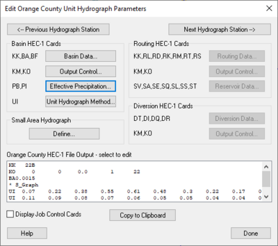
The Orange County Unit Hydrograph Parameters dialog is similar to the parameters dialog used by HEC-1. It contains the following options:
- Basin data
- Effective precipitation – Losses are included in the precipitation rather than defining a loss method
- Unit Hydrograph Method – Unit hydrographs are developed using Orange County S-graphs and lag time derived from the time of concentration computed in an Orange County Rational Method analysis
- Small Area Hydrograph
- Routing
- Stream/channel routing – A convex routing method is included in HEC-1
- Flow-through detention – Defines using reservoirs or storage routing in HEC-1
- Flow-by detention – Defines using diversions in HEC-1
Job Control
The Job Control dialog is used to define general information about the Orange County Unit Hydrograph model. The model uses the same Job Control dialog used by the HEC-1 model. Selecting the Job Control command from the HEC-1 or OC Hydrograph menu accesses this dialog. See the article HEC-1 Job Control for more information about this dialog.
For the OC hydrograph projects, note the following:
- Computational Time Interval
- The computational time interval entered here will be used to computed the effective precipitation and unit hydrograph.
- Expected Value Analysis
- Toggle this checkbox on to do an expected value analysis. Effective precipitation values and losses will be automatically updated for each sub-area if they have already been computed.
Orange County Storm
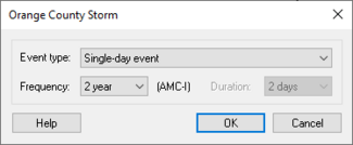
Define the point precipitation values that WMS will use to compute the design storm by selecting Define Storm in the OC Hydrograph menu. There are three types of storms: single-day event, multi-day event with flow-through detention, and multi-day event with flow-by detention. Choose a frequency and storm duration (for multi-day events). The antecedent moisture condition (AMC-I, AMC-II, AMC-III) that should be used to compute losses is displayed.
If the design storm event is changed, WMS automatically updates the effective precipitation for all sub-areas in which effective precipitation was previously defined.
Saving a Simulation
Save only the HEC-1 input files using the Save Simulation command in the OC Hydrograph menu. This will only save the hydrologic tree and the HEC-1 input parameters at each of the tree nodes. Terrain data, feature data, and GIS data will not be saved unless saving a WMS project file using the Save command in the File menu.
Post Processing
By default WMS will read in the hydrographs computed by HEC-1 and display small icons representing the hydrographs next to their corresponding tree nodes. It is possible to view a larger plot of the hydrograph by selecting a hydrograph icon and choosing the Open Hydrograph Plot in the Display menu or just by double-clicking the icon. Right-click on the hydrograph plot for options that format, print, and export the plot and its data.
Use the commands on the Hydrographs menu to open or delete HEC-1 results (*.sol file) as well as to view and export the data.
View the HEC-1 output file by using the Edit File command in the File menu to open the *.out file. This file provides a detailed report of the HEC-1 calculations.
Related Topics
- Orange County Hydrology
- Editing HEC-1 Parameters
- Small Area Hydrographs
- Using GIS Data
- Running a HEC-1 Analysis
WMS – Watershed Modeling System | ||
|---|---|---|
| Modules: | Terrain Data • Drainage • Map • Hydrologic Modeling • River • GIS • 2D Grid • 2D Scatter |  |
| Models: | CE-QUAL-W2 • GSSHA • HEC-1 • HEC-HMS • HEC-RAS • HSPF • MODRAT • NSS • OC Hydrograph • OC Rational • Rational • River Tools • Storm Drain • SMPDBK • SWMM • TR-20 • TR-55 | |
| Toolbars: | Modules • Macros • Units • Digitize • Static Tools • Dynamic Tools • Drawing • Get Data Tools | |
| Aquaveo | ||

