WMS:Digitize Toolbar: Difference between revisions
From XMS Wiki
Jump to navigationJump to search
No edit summary |
No edit summary |
||
| (10 intermediate revisions by the same user not shown) | |||
| Line 1: | Line 1: | ||
[[Image:WMSDigitize.png]] | [[Image:WMSDigitize.png|thumb|210 px|The Digitize toolbar]] | ||
The WMS ''Digitize Toolbar'' provides a quick way to create TIN vertices if there are known elevations and there is no source of accurate elevation data other than a digital map. | |||
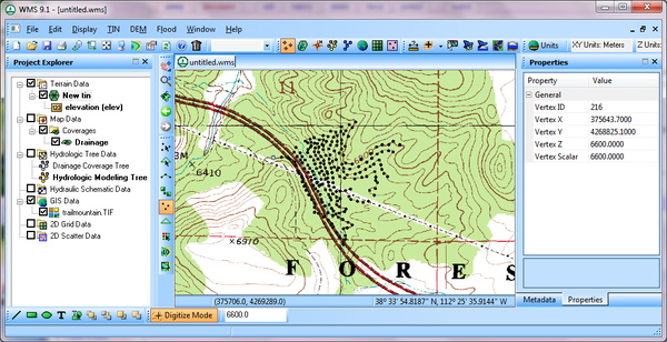
For example, if there is an image of a contour map with known contour elevations, turn on the ''Digitize Toolbar'' and then turn on '''Digitize Mode'''. Define an elevation value and then click on points along the contour to define vertices on a TIN, as shown below. | |||
[[Image:WMSUseDigitizeToolbar.png|thumb|none|600 px|Example of digitized points created along a TIN]] | |||
Once all the vertices have been defined on the TIN, turn off the digitize mode and triangulate the TIN to use the TIN in the hydrologic or hydraulic model. | |||
Once | |||
==Related Topics== | ==Related Topics== | ||
| Line 15: | Line 14: | ||
{{WMSMain}} | {{WMSMain}} | ||
[[Category:WMS Tools|D]] | |||
[[Category:WMS General Information|D]] | |||
Latest revision as of 16:36, 13 January 2016
The WMS Digitize Toolbar provides a quick way to create TIN vertices if there are known elevations and there is no source of accurate elevation data other than a digital map.
For example, if there is an image of a contour map with known contour elevations, turn on the Digitize Toolbar and then turn on Digitize Mode. Define an elevation value and then click on points along the contour to define vertices on a TIN, as shown below.
Once all the vertices have been defined on the TIN, turn off the digitize mode and triangulate the TIN to use the TIN in the hydrologic or hydraulic model.
Related Topics
WMS – Watershed Modeling System | ||
|---|---|---|
| Modules: | Terrain Data • Drainage • Map • Hydrologic Modeling • River • GIS • 2D Grid • 2D Scatter |  |
| Models: | CE-QUAL-W2 • GSSHA • HEC-1 • HEC-HMS • HEC-RAS • HSPF • MODRAT • NSS • OC Hydrograph • OC Rational • Rational • River Tools • Storm Drain • SMPDBK • SWMM • TR-20 • TR-55 | |
| Toolbars: | Modules • Macros • Units • Digitize • Static Tools • Dynamic Tools • Drawing • Get Data Tools | |
| Aquaveo | ||
