WMS:2D Grid Display Options: Difference between revisions
From XMS Wiki
Jump to navigationJump to search
No edit summary |
No edit summary |
||
| (9 intermediate revisions by the same user not shown) | |||
| Line 4: | Line 4: | ||
The grid display options are as follows: | The grid display options are as follows: | ||
*The | *The ''Nodes'' item is used to display grid nodes. Since all grids in WMS 7.0 are cell-centered, a dot is displayed at the cell centers. | ||
*The | *The'' Cells'' item is used to display the edges of active grid cells. The cells are drawn using the specified grid cell color and at the height set by the current elevation dataset. | ||
**The | **The ''cell style'' options dictate the form of the cells, whether smooth or block-style. The cells are both drawn and contoured in this style. | ||
: | :[[Image:GSSHA_Smooth_grid.png|thumb|none|300 px''Smoothed cells use interpolated values to match the cell corners.'']] | ||
:[[Image:GSSHA_Block_grid.png|thumb|none|300 px|''Blocked cells represent the cells as planar surfaces'']] | |||
| | |||
|''Smoothed cells use interpolated values to match the cell corners.'' | |||
| | |||
*The ''Grid Boundary'' item is used to display a solid line around the perimeter of the grid. Displaying the boundary is useful when contours are being displayed with the cell edges turned off. | |||
*The ''IJ Indices'' item is used to display the <math>ij</math> indices of each cell or node. | |||
*If the ''Inactive Cells'' item is used to display cells which are inactive. If this option is turned off, inactive cells are not displayed. Inactive cells must be displayed before they can be selected. | |||
*The ''Elevations'' item is used to display the z coordinate of each node or cell; the scalar item displays the active data set value for each cell. | |||
*The ''Contours'' item is used to display contours computed using the active scalar dataset. | |||
**The contours '''Options''' button accesses the contour options of the active dataset. Each gridded dataset has its own contours set. | |||
*The ''' | *The ''Lake Cells'' and ''Wetland Cells'' items are used to fill the cells whose centroids are contained within a lake or wetland polygon with the chosen color. | ||
*The '' | *The ''Flow Vectors'' item is used to display a set of arrows pointing from cell to cell that show which way water would flow from the cells based solely on elevation. An equals sign is displayed between the cells if the cells have the same elevation. | ||
*The ''Digital Dams'' item is used to mark those cells that are lower in elevation than the four lateral neighboring cells. | |||
*The '' | |||
:[[Image:GSSHA_flow_vectors.png|thumb|none|310 px|Represented here are flow vectors (blue arrows) that show the direction of flow from a cell to its neighboring cells as well as the cells which have been identified as digital dams (black square markers).]] | |||
: | |||
| | |||
| | |||
| Line 49: | Line 32: | ||
{{WMSMain}} | {{WMSMain}} | ||
[[Category:WMS 2D Grid|D]] | |||
[[Category:WMS Display Options|2]] | |||
[[Category:WMS 2D Grid Dialogs|D]] | |||
[[Category:WMS Display Dialogs]] | |||
Latest revision as of 14:56, 6 October 2017
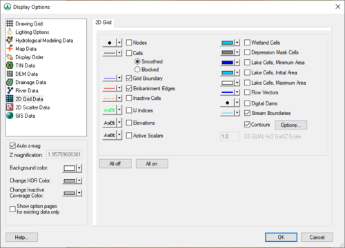
The display options control which components of the grid are displayed. The display options can be set by selecting the Display Options command in the Display menu. Most of the items in the dialog box are toggle boxes. If the toggle for a component of the grid is set, the component is displayed when the grid is redrawn. The color used to display the component can be set using the pop-up color window to the left of the toggle box.
The grid display options are as follows:
- The Nodes item is used to display grid nodes. Since all grids in WMS 7.0 are cell-centered, a dot is displayed at the cell centers.
- The Cells item is used to display the edges of active grid cells. The cells are drawn using the specified grid cell color and at the height set by the current elevation dataset.
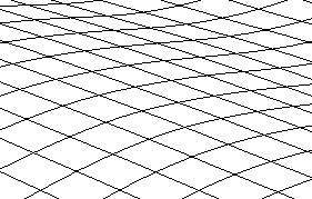
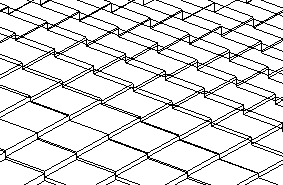
- The cell style options dictate the form of the cells, whether smooth or block-style. The cells are both drawn and contoured in this style.
- The Grid Boundary item is used to display a solid line around the perimeter of the grid. Displaying the boundary is useful when contours are being displayed with the cell edges turned off.
- The IJ Indices item is used to display the indices of each cell or node.
- If the Inactive Cells item is used to display cells which are inactive. If this option is turned off, inactive cells are not displayed. Inactive cells must be displayed before they can be selected.
- The Elevations item is used to display the z coordinate of each node or cell; the scalar item displays the active data set value for each cell.
- The Contours item is used to display contours computed using the active scalar dataset.
- The contours Options button accesses the contour options of the active dataset. Each gridded dataset has its own contours set.
- The Lake Cells and Wetland Cells items are used to fill the cells whose centroids are contained within a lake or wetland polygon with the chosen color.
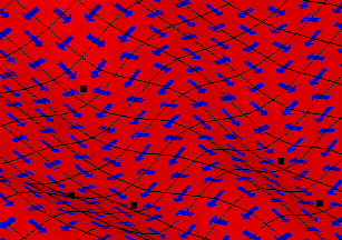
- The Flow Vectors item is used to display a set of arrows pointing from cell to cell that show which way water would flow from the cells based solely on elevation. An equals sign is displayed between the cells if the cells have the same elevation.
- The Digital Dams item is used to mark those cells that are lower in elevation than the four lateral neighboring cells.
Related Topics
| [hide] WMS – Watershed Modeling System | ||
|---|---|---|
| Modules: | Terrain Data • Drainage • Map • Hydrologic Modeling • River • GIS • 2D Grid • 2D Scatter |  |
| Models: | CE-QUAL-W2 • GSSHA • HEC-1 • HEC-HMS • HEC-RAS • HSPF • MODRAT • NSS • OC Hydrograph • OC Rational • Rational • River Tools • Storm Drain • SMPDBK • SWMM • TR-20 • TR-55 | |
| Toolbars: | Modules • Macros • Units • Digitize • Static Tools • Dynamic Tools • Drawing • Get Data Tools | |
| Aquaveo | ||


