WMS:MODRAT Job Control Parameters: Difference between revisions
From XMS Wiki
Jump to navigationJump to search
| Line 28: | Line 28: | ||
==Output Options== | ==Output Options== | ||
; Prefix for All Output Files : Enter the prefix for all output files that MODRAT will create when it runs (*.out, *.sum, *.out, etc.). This may be any name deemed appropriate. | |||
Enter the prefix for all output files that MODRAT will create when it runs (*.out, *.sum, *.out, etc.). This may be any name deemed appropriate | |||
; Reservoir Output Interval : Choose whether to use the standard MODRAT interval or specify a time interval (min) for MODRAT to output reservoir routing results. | |||
==Related Topics== | ==Related Topics== | ||
Revision as of 15:59, 12 October 2017
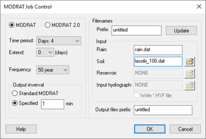
The Job Control dialog of MODRAT is used to set several options which affect the duration MODRAT will model and the data it will use for input. This dialog is pictured below.
Prefix for Files
Enter the prefix for MODRAT files (input and output), then click the Update Prefixes button to assign this prefix to the Reservoir file, Input hydrograph file, and output files listed in the Job Control dialog.
Input File Names
- Rain File
- Enter the name of the file that will contain the rainfall mass curves to be used by MODRAT. This file will be created by WMS—name it anything appropriate.
- Soil File
- The file containing soil type information for MODRAT should be entered in this field. This is generally the standard file created by the LACDPW named LASOILX.DAT.
- A user-defined soil type file may be created and the name entered in this field if any soil number not included in the standard file of 2-172 or 202-372 is used. This file must be sequentially numbered and be in the standard MODRAT soil file format. The easiest way to create this file is to copy the standard L.A. County Soil file (LASOILX.DAT), then add additional soil numbers and data to the end of it, beginning with number 373.
- Reservoir File
- Enter the name of the file that will contain the reservoir storage-capacity and elevation-discharge curves to be used by MODRAT. If having defined the reservoir with the Detention Basin Calculator in WMS, this file will be created by WMS – name it anything appropriate. If having manually created this file in the format required by MODRAT, enter the name of the file here.
- Input Hydrograph File
- If an input hydrograph has been specified at any location in the watershed, the name of the file containing the appropriate data must be entered here. The file must contain all input hydrographs for the watershed if more than one is specified; the order of the hydrographs in the file must be from upstream to downstream. In other words, if an input hydrograph is specified at 1A and 5B, the data for the hydrograph at 1A must come first in the input file, followed by the data for 5B. The format of the hydrograph data file is identical to the hydrograph output file created by MODRAT (the *.hyf file).
- Toggle the Write *.HYF check box on to have WMS write the *.hyf file using input hydrograph data that was entered in the Edit MODRAT Parameters dialog.
Rainfall Distribution
- Time Period
- MODRAT can be run to calculate runoff for 4 different time periods:
- Days 1, 2, 3, 4 of a four day storm
- Days 2, 3, 4 of a four day storm
- Days 3, 4 of a four day storm
- Day 4 of a four day storm
- Frequency
- The frequency chosen in the Job Control dialog does not affect the MODRAT computations. It is, however, included for reference in output from MODRAT.
Output Options
- Prefix for All Output Files
- Enter the prefix for all output files that MODRAT will create when it runs (*.out, *.sum, *.out, etc.). This may be any name deemed appropriate.
- Reservoir Output Interval
- Choose whether to use the standard MODRAT interval or specify a time interval (min) for MODRAT to output reservoir routing results.
Related Topics
WMS – Watershed Modeling System | ||
|---|---|---|
| Modules: | Terrain Data • Drainage • Map • Hydrologic Modeling • River • GIS • 2D Grid • 2D Scatter |  |
| Models: | CE-QUAL-W2 • GSSHA • HEC-1 • HEC-HMS • HEC-RAS • HSPF • MODRAT • NSS • OC Hydrograph • OC Rational • Rational • River Tools • Storm Drain • SMPDBK • SWMM • TR-20 • TR-55 | |
| Toolbars: | Modules • Macros • Units • Digitize • Static Tools • Dynamic Tools • Drawing • Get Data Tools | |
| Aquaveo | ||
