WMS:OC Rational Tree Mapping: Difference between revisions
From XMS Wiki
Jump to navigationJump to search
No edit summary |
No edit summary |
||
| Line 8: | Line 8: | ||
'''Mapped Results''' – Contains a list of those basins that have been mapped to concentration points | '''Mapped Results''' – Contains a list of those basins that have been mapped to concentration points | ||
Use the arrow keys ( | Use the arrow keys (→ and '''←''') to map and unmap selections. | ||
Revision as of 15:37, 16 October 2017
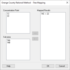
When building a Orange County Rational simulation, where GIS or map data is not available, the Tree Mapping dialog can be used to map concentration points to related downstream basins. The reason for this is the possibility of numerous downstream basins being present, thus allowing for the mapping of basins to the correct upstream terminus.
Concentration Point – Contains a list of concentration points that have not been mapped
Sub-area – Contains a list of all possible basins that can be mapped to the selected concentration point
Mapped Results – Contains a list of those basins that have been mapped to concentration points
Use the arrow keys (→ and ←) to map and unmap selections.
Related Topics
WMS – Watershed Modeling System | ||
|---|---|---|
| Modules: | Terrain Data • Drainage • Map • Hydrologic Modeling • River • GIS • 2D Grid • 2D Scatter |  |
| Models: | CE-QUAL-W2 • GSSHA • HEC-1 • HEC-HMS • HEC-RAS • HSPF • MODRAT • NSS • OC Hydrograph • OC Rational • Rational • River Tools • Storm Drain • SMPDBK • SWMM • TR-20 • TR-55 | |
| Toolbars: | Modules • Macros • Units • Digitize • Static Tools • Dynamic Tools • Drawing • Get Data Tools | |
| Aquaveo | ||
