WMS:Project Explorer Contents for Hydrologic Modeling Module: Difference between revisions
No edit summary |
No edit summary |
||
| Line 12: | Line 12: | ||
:[[Image:WMS_HydrologicProjectExplorer3.png]] | :[[Image:WMS_HydrologicProjectExplorer3.png]] | ||
Right-clicking on a basin or outlet | Right-clicking on a basin [[File:Drainage Module Icon.svg|16 px]] or outlet [[File:HydrologicStationData.svg|16 px]] icon gives the option to '''Rename''' that basin (remember that HEC-1 names should be six characters or less) or '''Edit Parameters''' for the currently active model. Selecting a basin or outlet will cause it to be selected in the topologic tree of the graphics window. | ||
:[[Image:WMS_HydrologicProjectExplorer4.png]] | :[[Image:WMS_HydrologicProjectExplorer4.png]] | ||
Revision as of 15:57, 3 May 2018
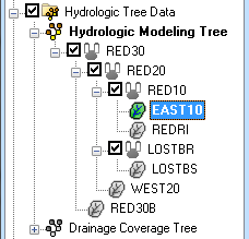
In the hydrologic modeling module the Project Explorer displays the identical structure as the topologic tree providing an alternate hierarchical view of the hydrologic model (diversions are not displayed in the Project Explorer). A check box controlling the display of an entire folder (model) and outlet points is displayed to the left of the icon. If unchecking an outlet then the display of that outlet, it's basins and everything "upstream" of the outlet will not be displayed in the tree display of the graphics window.
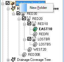
Right-clicking on the main Hydrologic Tree Data folder ![]() allows creating a new folder (at this point a topologic tree for hydrologic model cannot be created directly from the Project Explorer).
allows creating a new folder (at this point a topologic tree for hydrologic model cannot be created directly from the Project Explorer).
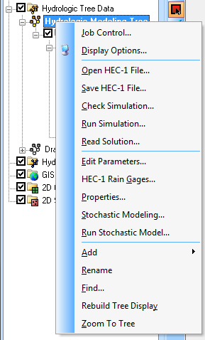
Right-clicking on the Hydrologic Modeling Tree object ![]() will bring up a menu with commands for the current hydrologic model.
will bring up a menu with commands for the current hydrologic model.
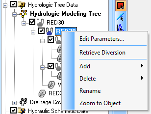
Right-clicking on a basin ![]() or outlet
or outlet ![]() icon gives the option to Rename that basin (remember that HEC-1 names should be six characters or less) or Edit Parameters for the currently active model. Selecting a basin or outlet will cause it to be selected in the topologic tree of the graphics window.
icon gives the option to Rename that basin (remember that HEC-1 names should be six characters or less) or Edit Parameters for the currently active model. Selecting a basin or outlet will cause it to be selected in the topologic tree of the graphics window.
Related Topic
WMS – Watershed Modeling System | ||
|---|---|---|
| Modules: | Terrain Data • Drainage • Map • Hydrologic Modeling • River • GIS • 2D Grid • 2D Scatter |  |
| Models: | CE-QUAL-W2 • GSSHA • HEC-1 • HEC-HMS • HEC-RAS • HSPF • MODRAT • NSS • OC Hydrograph • OC Rational • Rational • River Tools • Storm Drain • SMPDBK • SWMM • TR-20 • TR-55 | |
| Toolbars: | Modules • Macros • Units • Digitize • Static Tools • Dynamic Tools • Drawing • Get Data Tools | |
| Aquaveo | ||


