WMS:HEC-HMS User Hyetograph: Difference between revisions
From XMS Wiki
Jump to navigationJump to search
No edit summary |
No edit summary |
||
| Line 1: | Line 1: | ||
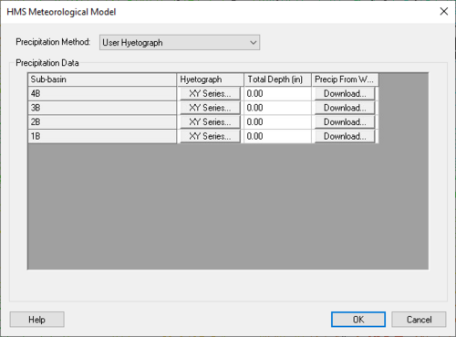
The User Hyetograph method can be used if a hyetograph is known for each sub-basin of the watershed being modeled. A user can get this hyetograph from recorded data or from any other method. A user can enter the same or different hyetographs for each basin, but each basin can only have a single hyetograph. Define the hyetograph by clicking on the '''XY Series''' button in the ''HMS Meteorological Model'' dialog shown below, and define the hyetograph in the XY series editor: | The User Hyetograph method can be used if a hyetograph is known for each sub-basin of the watershed being modeled. A user can get this hyetograph from recorded data or from any other method. A user can enter the same or different hyetographs for each basin, but each basin can only have a single hyetograph. Define the hyetograph by clicking on the '''XY Series''' button in the ''HMS Meteorological Model'' dialog shown below, and define the hyetograph in the XY series editor: | ||
[[Image:HMSUserHyetograph1.jpg|thumb|none|left|500 px|''HMS Meteorological Model'' dialog]] | [[Image:HMSUserHyetograph1.jpg|thumb|none|left|500 px|''HMS Meteorological Model'' dialog for the "User Hyetograph" method.]] | ||
== Related Topics: == | == Related Topics: == | ||
Revision as of 17:34, 4 September 2014
The User Hyetograph method can be used if a hyetograph is known for each sub-basin of the watershed being modeled. A user can get this hyetograph from recorded data or from any other method. A user can enter the same or different hyetographs for each basin, but each basin can only have a single hyetograph. Define the hyetograph by clicking on the XY Series button in the HMS Meteorological Model dialog shown below, and define the hyetograph in the XY series editor:
Related Topics:
WMS – Watershed Modeling System | ||
|---|---|---|
| Modules: | Terrain Data • Drainage • Map • Hydrologic Modeling • River • GIS • 2D Grid • 2D Scatter |  |
| Models: | CE-QUAL-W2 • GSSHA • HEC-1 • HEC-HMS • HEC-RAS • HSPF • MODRAT • NSS • OC Hydrograph • OC Rational • Rational • River Tools • Storm Drain • SMPDBK • SWMM • TR-20 • TR-55 | |
| Toolbars: | Modules • Macros • Units • Digitize • Static Tools • Dynamic Tools • Drawing • Get Data Tools | |
| Aquaveo | ||
