WMS:What's new in WMS version 8.1: Difference between revisions
m (Protected "WMS:What's new in WMS version 8.1" ([Edit=Allow only administrators] (indefinite) [Move=Allow only administrators] (indefinite))) |
|
(No difference)
| |
Revision as of 14:27, 12 September 2016
The WMS software development team is excited about the release of WMS 8.1! This page lists the exciting new features that have been added to WMS 8.1.
Model Enhancements
Hydrologic Modeling
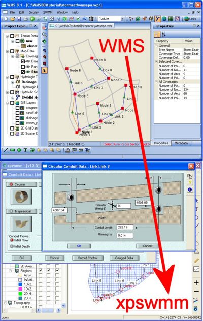
Storm water quality and quantity modeling with xpswmm and EPA SWMM interfaces
The Storm Water Management Model (SWMM) is a popular model used to simulate the hydrology and hydraulics of storm water runoff. SWMM is primarily used for urban areas, and can be used to model single event or long-term (continuous) simulation of runoff quantity and quality.
With WMS 8.1, you can delineate a watershed and then export the delineated watershed boundaries and the WMS-computed watershed data to xpswmm or EPA SWMM.
| width=400|height=420|bgcolor=white|scale=noborder|align=right</flash> |
Spatially Distributed Hydrologic Modeling with GSSHA™
New to WMS 8.1 is full support and documentation for the distributed hydrologic model GSSHA™. Several improvements have been made to the GSSHA™ interface in WMS 8.1. The entire process of creating GSSHA™ models and running GSSHA™ models has been streamlined in the Hydrologic Modeling Wizard. The water quality modeling interface and capabilities of GSSHA™ have been significantly improved. Nutrient modeling capabilities have also been improved. Several post-processing features have also been added that allow you to more effectively view water depth along each of the stream channels in the GSSHA™ model. We have added two new tutorials and a new volume (Volume 6) to our list of WMS tutorials that walk you through the process of setting up a basic GSSHA™ model with overland flow and stream routing and using NEXRAD Radar precipitation with your GSSHA™ model. A new web site, gsshawiki.com, has also been launched. This web site contains all the latest GSSHA™ documentation and a wealth of information for GSSHA™ modeling.
HMS gridded rainfall (NEXRAD) support
WMS 8.1 supports an exciting new feature that makes it easier to work with quasi-distributed hydrologic models. This feature makes it simple for you to use NEXRAD RADAR rainfall data in XMRG format, such as archived rainfall data from the National Weather Service. This feature allows you to read a set of NEXRAD rainfall grids and compute the Thiessen polygon-based gage weights for each sub-basin and the total precipitation (or a precipitation distribution) for each gage based on the rainfall grids.
WMS 8.1 also has features that allow you to convert radar-derived precipitation grids directly to formats that can be used in two different hydrologic models: The quasi-distributed MODClark model, which is part of the HMS interface and the distributed GSSHA™ model.
Improved HMS interface and MODClark modeling support
Several improvements have been made to the HMS interface in WMS 8.1.
One of the most exciting improvements allows you to define a grid representing an HMS MODClark model at any resolution and compute a Curve Number, rainfall value, and travel time at each cell on the grid. After defining the MODClark model in WMS, you can export the model to HMS and run the MODClark simulation. The powerful MODClark modeling capabilities in WMS are not available in any other software product.
Hydraulic Modeling
Storm water quality and quantity modeling with xpswmm and EPA SWMM interfaces
Besides supporting hydrologic modeling with xpswmm and EPA SWMM, WMS supports hydraulic modeling through the "Storm Drain" coverage and the River module. You can import or draw a conceptual model of your storm drain networks in the storm drain coverage and then convert your conceptual model to a schematic in the River module. From the river module, you can export your storm drain network to xpswmm or EPA SWMM where the model can be run. Using the new WMS feature to export (and import) xpswmm and EPA SWMM files, you can build your model and perform model computations in the familiar and GIS-enabled WMS interface. After building and defining your model in WMS, you can export your model to SWMM and finish your model and view the results in the SWMM interface.
Updated HY-8 7.1 culvert analysis computations and an improved interface
WMS 8.1 has an improved interface with the FHWA HY-8 culvert analysis program. Since HY-8 7.1 was developed by Aquaveo (the developers of WMS), we were able to integrate the HY-8 7.1 culvert analysis interface and code directly into WMS. With the new HY-8 Culvert coverage, you can define the location of your culvert and edit the data associated with a culvert. The WMS software developers have also linked the HY-8 culvert coverage with the detention basin calculator, allowing you to route a hydrograph through a culvert and determine the effect of the culvert on the hydrograph. The WMS HY-8 interface offers report generation, energy dissipation structure analysis capabilities, and many other powerful features directly within the WMS interface.
Improved support of FHWA hydraulic modeling tools
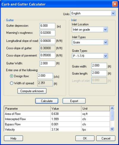
WMS 8.1 has improved the support of the FHWA hydraulic modeling tools. The channel calculator, weir calculator, and the curb and gutter calculator have all been improved to more effectively coincide with FHWA's HEC 22 computation guidelines.
General Enhancements
In WMS 8.1, the "Get Data" toolbar has been expanded to include two new buttons: The "Get Data From Map" button and the "Hydrologic Modeling Wizard" button:
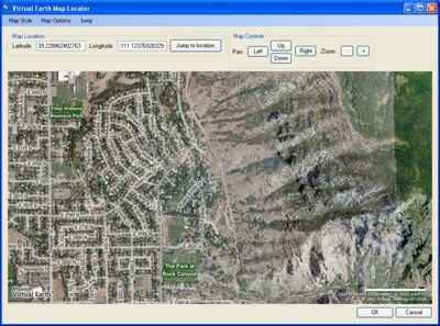
Virtual Earth map locator tool
The "Get Data From Map" button brings up the WMS Virtual Earth map locator tool. This tool is powered by Microsoft Virtual Earth, and accesses data from the internet to allow you to view maps anywhere in the world. Once you zoom into the region you're interested in modeling, WMS will bring up a web data service client which will allow you to select from several data download options. From this dialog, you can select to download NED (DEM), Land Use, or Microsoft TerraServer aerial imagery and topographic data. The data you select is downloaded and read into WMS. This powerful combination of tools will allow you to streamline your data collection process so much of your data collection can be done within the WMS interface.
Improved web service client tools
Along with the virtual earth map locator tools, the web service client capabilities of WMS have been greatly improved. In previous versions of WMS, WMS had difficulties downloading data. Many of these difficulties originate from the web service servers, and WMS cannot improve much on these problems. However, the WMS developers have streamlined our web service client tools to give you feedback on the status of your downloads and to fix several problems that were in previous version of the web service client.
Hydrologic modeling wizard
The "Hydrologic Modeling Wizard" button in the Get Data toolbar steps you through the process of building a hydrologic model. This powerful wizard starts by helping you define your project coordinate system and gather your data, then steps you through the process of delineating your watershed and computing the parameters for your hydrologic model. When you are done with the wizard, you will have a hydrologic model that is completed or nearly completed for any of the hydrologic models supported in WMS.
Improved graphics
The WMS graphics display speed has been dramatically increased. Previous versions of WMS used a software-based approach to rendering your data, but WMS 8.1 uses your graphics hardware to render your data. Along with this modification, the WMS software developers have added Windows Vista graphics support to WMS 8.1.

A new user-editable WMS "Wiki" online help
The WMS software developers have developed the xmswiki.com home page. Instead of the traditional WMS help file, all the help is now available online from the xmswiki.com site. This help site uses the "Mediawiki" engine, which is the same code base used by Wikipedia to run their site. This means that anybody who knows about WMS, including you, can modify a help topic or create a new topic. Be assured that the WMS software developers will monitor changes to the WMS wiki, so the xmswiki.com content will be accurate. But with this powerful online editing tool, the WMS help will be much more comprehensive and up-to-date. The xmswiki.com site also features a Google search engine, bringing the power of Google search to the WMS help pages.
XMDF file I/O
The WMS 8.1 file format has been modified to use the XMDF file format as the default format. This format provides for faster WMS file I/O and good WMS file viewing capabilities with the NCSA HDFView editor which can be used to edit any XMDF-formatted file.
WMS – Watershed Modeling System | ||
|---|---|---|
| Modules: | Terrain Data • Drainage • Map • Hydrologic Modeling • River • GIS • 2D Grid • 2D Scatter |  |
| Models: | CE-QUAL-W2 • GSSHA • HEC-1 • HEC-HMS • HEC-RAS • HSPF • MODRAT • NSS • OC Hydrograph • OC Rational • Rational • River Tools • Storm Drain • SMPDBK • SWMM • TR-20 • TR-55 | |
| Toolbars: | Modules • Macros • Units • Digitize • Static Tools • Dynamic Tools • Drawing • Get Data Tools | |
| Aquaveo | ||


