WMS:TR-55: Difference between revisions
No edit summary |
No edit summary |
||
| Line 2: | Line 2: | ||
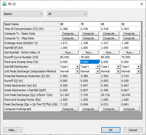
TR-55 models can be defined in WMS using the commands in the ''TR-55'' menu and resulting dialogs. The TR-55 model has long been used to determine the increase in runoff resulting from the development of rural land into urban land. The WMS interface to TR-55, combined with the basin delineation and time of concentration calculations from feature objects (see [[WMS:Lag Time and Time of Concentration|Lag Time and Time of Concentration]]), makes it simple to set up and run several different scenarios in a relatively short time period. | TR-55 models can be defined in WMS using the commands in the ''TR-55'' menu and resulting dialogs. The TR-55 model has long been used to determine the increase in runoff resulting from the development of rural land into urban land. The WMS interface to TR-55, combined with the basin delineation and time of concentration calculations from feature objects (see [[WMS:Lag Time and Time of Concentration|Lag Time and Time of Concentration]]), makes it simple to set up and run several different scenarios in a relatively short time period. | ||
This section describes the mechanics of the WMS interface to TR-55 and is not a complete reference to the methodology, uses, and limitations. For more in depth information, read [ | This section describes the mechanics of the WMS interface to TR-55 and is not a complete reference to the methodology, uses, and limitations. For more in depth information, read ''[http://www.nrcs.usda.gov/Internet/FSE_DOCUMENTS/stelprdb1044171.pdf Technical Release 55: Urban Hydrology for Small Watersheds, 2nd Edition.]'' | ||
WMS uses its own format for saving or reading a TR-55 simulation. When in the Hydrologic Modeling Module, select ''TR-55'' from the drop-down list of models to make TR-55 the active model. To edit the TR-55 parameters and run a TR-55 simulation, select the outlets or basins to edit and/or run and select the '''Run Simulation''' menu item from the ''TR-55'' menu. | WMS uses its own format for saving or reading a TR-55 simulation. When in the Hydrologic Modeling Module, select ''TR-55'' from the drop-down list of models to make TR-55 the active model. To edit the TR-55 parameters and run a TR-55 simulation, select the outlets or basins to edit and/or run and select the '''Run Simulation''' menu item from the ''TR-55'' menu. | ||
| Line 12: | Line 12: | ||
* [[WMS:TR-55 Outlet Data|Outlet Data]] | * [[WMS:TR-55 Outlet Data|Outlet Data]] | ||
* [[WMS:TR-55 Hydrographs|Hydrographs]] | * [[WMS:TR-55 Hydrographs|Hydrographs]] | ||
==External Links== | |||
* [http://www.wcc.nrcs.usda.gov/ftpref/wntsc/H&H/WinTR55/WinTR55UserGuide.pdf TR-55 User Guide] | |||
Revision as of 15:12, 14 September 2016
TR-55 models can be defined in WMS using the commands in the TR-55 menu and resulting dialogs. The TR-55 model has long been used to determine the increase in runoff resulting from the development of rural land into urban land. The WMS interface to TR-55, combined with the basin delineation and time of concentration calculations from feature objects (see Lag Time and Time of Concentration), makes it simple to set up and run several different scenarios in a relatively short time period.
This section describes the mechanics of the WMS interface to TR-55 and is not a complete reference to the methodology, uses, and limitations. For more in depth information, read Technical Release 55: Urban Hydrology for Small Watersheds, 2nd Edition.
WMS uses its own format for saving or reading a TR-55 simulation. When in the Hydrologic Modeling Module, select TR-55 from the drop-down list of models to make TR-55 the active model. To edit the TR-55 parameters and run a TR-55 simulation, select the outlets or basins to edit and/or run and select the Run Simulation menu item from the TR-55 menu.
The TR-55 model is included will all paid editions of WMS.
Related Topics
External Links
WMS – Watershed Modeling System | ||
|---|---|---|
| Modules: | Terrain Data • Drainage • Map • Hydrologic Modeling • River • GIS • 2D Grid • 2D Scatter |  |
| Models: | CE-QUAL-W2 • GSSHA • HEC-1 • HEC-HMS • HEC-RAS • HSPF • MODRAT • NSS • OC Hydrograph • OC Rational • Rational • River Tools • Storm Drain • SMPDBK • SWMM • TR-20 • TR-55 | |
| Toolbars: | Modules • Macros • Units • Digitize • Static Tools • Dynamic Tools • Drawing • Get Data Tools | |
| Aquaveo | ||
