WMS:Orange County Unit Hydrograph: Difference between revisions
From XMS Wiki
Jump to navigationJump to search
No edit summary |
No edit summary |
||
| Line 10: | Line 10: | ||
* [[WMS:Routing HEC-1 Cards|Routing]] | * [[WMS:Routing HEC-1 Cards|Routing]] | ||
*# Stream/channel routing – a [[WMS:Routing HEC-1 Cards|convex routing method]] is included in HEC-1 | *# Stream/channel routing – a [[WMS:Routing HEC-1 Cards|convex routing method]] is included in HEC-1 | ||
*# Flow-through detention – define using [[WMS:Routing HEC-1 Cards|reservoirs]] or [[WMS:HEC-1 | *# Flow-through detention – define using [[WMS:Routing HEC-1 Cards|reservoirs]] or [[WMS:Routing HEC-1 Cards|storage routing]] in HEC-1 | ||
*# Flow-by detention – define using [[WMS:Diversion HEC-1 Cards|diversions]] in HEC-1 | *# Flow-by detention – define using [[WMS:Diversion HEC-1 Cards|diversions]] in HEC-1 | ||
Revision as of 22:32, 12 February 2013
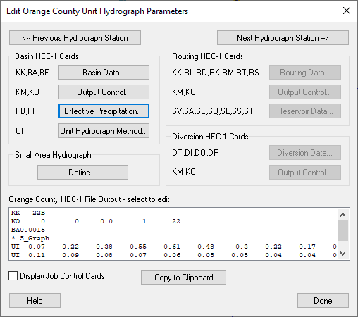
Unit hydrograph analysis is used for watersheds greater than 1 square mile (640 acres) in Orange County, California. Losses are accounted for by calculating an effective precipitation. Runoff hydrographs are computed using a unit hydrograph, which is developed using an S-graph. You can use a small area hydrograph instead of a full blown unit hydrograph analysis for watersheds with a Tc < 25 min. WMS creates the input files required for HEC-1 to compute hydrographs for the Orange County unit hydrograph analysis. Much of the interface for the Orange County unit hydrograph analysis is similar to the HEC-1 interface within WMS. Some of the processes specific to Orange County are described below:
- Basin data
- Effective precipitation – losses are included in the precipitation rather than defining a loss method
- Unit Hydrograph Method – unit hydrographs are developed using Orange County S-graphs and lag time derived from the time of concentration computed in an Orange County Rational Method analysis
- Routing
- Stream/channel routing – a convex routing method is included in HEC-1
- Flow-through detention – define using reservoirs or storage routing in HEC-1
- Flow-by detention – define using diversions in HEC-1
Related Topics
- Orage County Hydrology
- Editing HEC-1 Parameters
- Job Control
- Design Storms
- Small Area Hydrographs
- Using GIS Data
- Running a HEC-1 Analysis
- Saving a Simulation
- Post Processing
WMS – Watershed Modeling System | ||
|---|---|---|
| Modules: | Terrain Data • Drainage • Map • Hydrologic Modeling • River • GIS • 2D Grid • 2D Scatter |  |
| Models: | CE-QUAL-W2 • GSSHA • HEC-1 • HEC-HMS • HEC-RAS • HSPF • MODRAT • NSS • OC Hydrograph • OC Rational • Rational • River Tools • Storm Drain • SMPDBK • SWMM • TR-20 • TR-55 | |
| Toolbars: | Modules • Macros • Units • Digitize • Static Tools • Dynamic Tools • Drawing • Get Data Tools | |
| Aquaveo | ||
