WMS:Drainage Module Feature Objects: Difference between revisions
From XMS Wiki
Jump to navigationJump to search
(Created page with "The drainage module has a number of tools to edit feature objects. The dialogs can be reached by double-clicking on feature object or by selecting the feature object then select...") |
No edit summary |
||
| Line 1: | Line 1: | ||
The drainage module has a number of tools to edit feature objects. The dialogs can be reached by double-clicking on feature object or by selecting the feature object then selecting '''Attributes''' from the ''Feature Objects'' Menu. | The drainage module has a number of tools to edit feature objects. The dialogs can be reached by double-clicking on feature object or by selecting the feature object then selecting '''Attributes''' from the ''Feature Objects'' Menu. | ||
==Feature Arc Type== | |||
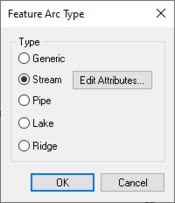
[[Image:WMS Drainage Feature Arc Type.jpg|thumb|175 px|Drainage ''Feature Arc Type'' dialog]] | |||
This dialog is accessed by selecting a feature arc. The type of arc can be selected from this dialog. Available types are: | |||
* Generic | |||
* Stream | |||
* Pipe | |||
* Lake | |||
* Ridge | |||
Selecting the ''Stream'' option makes the '''Edit Attributes''' button active. Clicking on this button will bring up the ''Edit Stream Arc Attributes'' dialog. | |||
{{WMSMain}} | {{WMSMain}} | ||
Revision as of 21:56, 16 May 2013
The drainage module has a number of tools to edit feature objects. The dialogs can be reached by double-clicking on feature object or by selecting the feature object then selecting Attributes from the Feature Objects Menu.
Feature Arc Type
This dialog is accessed by selecting a feature arc. The type of arc can be selected from this dialog. Available types are:
- Generic
- Stream
- Pipe
- Lake
- Ridge
Selecting the Stream option makes the Edit Attributes button active. Clicking on this button will bring up the Edit Stream Arc Attributes dialog.
WMS – Watershed Modeling System | ||
|---|---|---|
| Modules: | Terrain Data • Drainage • Map • Hydrologic Modeling • River • GIS • 2D Grid • 2D Scatter |  |
| Models: | CE-QUAL-W2 • GSSHA • HEC-1 • HEC-HMS • HEC-RAS • HSPF • MODRAT • NSS • OC Hydrograph • OC Rational • Rational • River Tools • Storm Drain • SMPDBK • SWMM • TR-20 • TR-55 | |
| Toolbars: | Modules • Macros • Units • Digitize • Static Tools • Dynamic Tools • Drawing • Get Data Tools | |
| Aquaveo | ||
