WMS:Weir Calculator: Difference between revisions
No edit summary |
No edit summary |
||
| Line 1: | Line 1: | ||
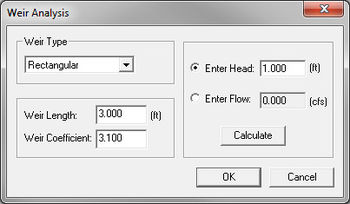
[[Image:WMS Weir Calculator.jpg|thumb|350 px|''Weir Analysis'' dialog]] | |||
Head or flow over a weir can be determined using the ''Weir Calculations'' dialog. If flow is to be calculated then head over the weir must be entered as an input. If head is to be computed then a flow rate must be entered as input. The weir calculator uses the standard equation for computing flow over a weir: | Head or flow over a weir can be determined using the ''Weir Calculations'' dialog. If flow is to be calculated then head over the weir must be entered as an input. If head is to be computed then a flow rate must be entered as input. The weir calculator uses the standard equation for computing flow over a weir: | ||
Revision as of 20:42, 28 May 2013
Head or flow over a weir can be determined using the Weir Calculations dialog. If flow is to be calculated then head over the weir must be entered as an input. If head is to be computed then a flow rate must be entered as input. The weir calculator uses the standard equation for computing flow over a weir:
where:
– discharge flow (volume/time)
– weir coefficient
– width of weir (distance, ft or m)
– head (distance, ft or m)
If a hydrograph has been computed using one of the supported hydrologic model, the peak flow for the hydrograph will be used as the default flow value if the hydrograph is selected prior to opening the dialog.
Selection of one of the predefined weir types automatically assigns the appropriate weir coefficient. A user-defined weir coefficient can also be entered, or the default value for one of the weir types listed modified. Weir calculations can also be used in combination with the detention basin calculator to define any outlet works of the basin/reservoir.
The weir calculator uses the Hydraulic Toolbox to perform the calculations.
Related Topics
WMS – Watershed Modeling System | ||
|---|---|---|
| Modules: | Terrain Data • Drainage • Map • Hydrologic Modeling • River • GIS • 2D Grid • 2D Scatter |  |
| Models: | CE-QUAL-W2 • GSSHA • HEC-1 • HEC-HMS • HEC-RAS • HSPF • MODRAT • NSS • OC Hydrograph • OC Rational • Rational • River Tools • Storm Drain • SMPDBK • SWMM • TR-20 • TR-55 | |
| Toolbars: | Modules • Macros • Units • Digitize • Static Tools • Dynamic Tools • Drawing • Get Data Tools | |
| Aquaveo | ||


