WMS:NSS Computing Peak Discharges: Difference between revisions
From XMS Wiki
Jump to navigationJump to search
No edit summary |
|||
| Line 11: | Line 11: | ||
==National Streamline Statistics Method Dialog Overview== | ==National Streamline Statistics Method Dialog Overview== | ||
The NSS regression equations are separated by state. The ''State'' drop down menu is used to specify the state that the watershed is located in. Once the state is specified, the available regions will appear in the regional equations text window. Besides the 50 US states, an equation for Puerto Rico and a custom defined equation can be selected from the available choices. | |||
==Related Topics== | ==Related Topics== | ||
Revision as of 17:31, 10 June 2015
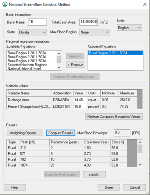
Setting up the analysis consists of the following steps, all done within the National Streamline Statistics Method dialog. The dialog can be used to do the follow:
- Delineate the watershed and compute the basin area and other geometric parameters. Enter the value manually if not having delineated from a DEM, drainage coverage, or TIN.
- Select the state the watershed is in and assign the Maximum Flood Region.
- Select the region equation that the watershed is in and while highlighted from the Available Equations window choose the Select button so that it will be listed in the Selected Equations window. If the watershed overlaps more than one region then select the other regions as well.
- Variable values derived from a DEM or Drainage coverage will automatically be placed in the appropriate edit fields. Other variables not computed will need to be defined.
- Select the Compute Results button to estimate the peak flows for the 2, 5, 10, 25, 50, 100 and 500-year recurrence intervals.
A hydrograph can be estimated by selecting one of the peak flow rows from the Results table and choosing the Compute Hydrograph button.
National Streamline Statistics Method Dialog Overview
The NSS regression equations are separated by state. The State drop down menu is used to specify the state that the watershed is located in. Once the state is specified, the available regions will appear in the regional equations text window. Besides the 50 US states, an equation for Puerto Rico and a custom defined equation can be selected from the available choices.
Related Topics
WMS – Watershed Modeling System | ||
|---|---|---|
| Modules: | Terrain Data • Drainage • Map • Hydrologic Modeling • River • GIS • 2D Grid • 2D Scatter |  |
| Models: | CE-QUAL-W2 • GSSHA • HEC-1 • HEC-HMS • HEC-RAS • HSPF • MODRAT • NSS • OC Hydrograph • OC Rational • Rational • River Tools • Storm Drain • SMPDBK • SWMM • TR-20 • TR-55 | |
| Toolbars: | Modules • Macros • Units • Digitize • Static Tools • Dynamic Tools • Drawing • Get Data Tools | |
| Aquaveo | ||
