WMS:Model Selection: Difference between revisions
From XMS Wiki
Jump to navigationJump to search
No edit summary |
No edit summary |
||
| Line 1: | Line 1: | ||
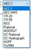
When a module supports several models such as the Map module or the Hydrologic modeling module then WMS will only display the menu (and associated commands) for the active model. The active model is set using the drop-down combo box at the right side of the edit window. | When a module supports several models such as the Map module or the Hydrologic modeling module then WMS will only display the menu (and associated commands) for the active model. The active model is set using the drop-down combo box at the right side of the edit window. | ||
[[Image:WMSmodelSelector.png|right|100 px]] | [[Image:WMSmodelSelector.png|thumb|right|100 px|The model selection menu]] | ||
*The Models available in the [[WMS:Map Module|Map Module]] are: | *The Models available in the [[WMS:Map Module|Map Module]] are: | ||
Revision as of 00:03, 21 January 2016
When a module supports several models such as the Map module or the Hydrologic modeling module then WMS will only display the menu (and associated commands) for the active model. The active model is set using the drop-down combo box at the right side of the edit window.
- The Models available in the Map Module are:
- The Models available in the Hydrologic Modeling Module are:
- The Models available in the River/Hydraulic Module are:
How to select a model
Do I want to do hydrology or hydraulics?
- Hydraulics:
- Do I want to do a simple dam break simulation?
- SMPDBK (Simplified Dam Break)
- Do I want to do floodplain delineation, hydraulics, or a more complicated dam break simulation?
- Do I want to model storm drains?
- Do I want to do a simple dam break simulation?
- Hydrology:
- Am I doing a small urban model?
- Am I doing a rural model?
- Am I interested in water quality, sediment transport, or the effects of wetlands on a hydrograph
Related Topics
WMS – Watershed Modeling System | ||
|---|---|---|
| Modules: | Terrain Data • Drainage • Map • Hydrologic Modeling • River • GIS • 2D Grid • 2D Scatter |  |
| Models: | CE-QUAL-W2 • GSSHA • HEC-1 • HEC-HMS • HEC-RAS • HSPF • MODRAT • NSS • OC Hydrograph • OC Rational • Rational • River Tools • Storm Drain • SMPDBK • SWMM • TR-20 • TR-55 | |
| Toolbars: | Modules • Macros • Units • Digitize • Static Tools • Dynamic Tools • Drawing • Get Data Tools | |
| Aquaveo | ||
