WMS:Conceptual Model: Difference between revisions
No edit summary |
No edit summary |
||
| Line 1: | Line 1: | ||
A conceptual model is a map-based representation of | A conceptual model is a map-based representation of the hydrologic or hydraulic model using map module objects (feature objects) such as points, nodes, arcs, and polygons. To define and compute lumped-parameter model data, WMS normally converts a map module representation of the model to a schematic or tree-based representation of the model in either the hydrologic modeling or river module. When creating a conceptual model of ''hydrologic'' data (basins, streams, and outlet points), the schematic representation is created automatically. When creating a conceptual model of ''hydraulic'' data, the schematic representation is created by selecting the [[WMS:Storm Drain#Storm Drain Menu|'''Map→1D Schematic''']] menu item available in the special menu associated with the hydraulic modeling coverage (This command is available in 1D Hydraulic Schematic and Storm Drain coverages). After selecting the '''Map→1D Schematic''' command, cross sections, reaches, links, and/or nodes are displayed as symbols in the river module and their properties can be edited in that module. | ||
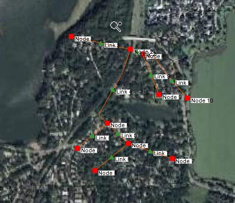
As an example, a SWMM hydraulic model with arcs representing links and nodes in a SWMM model and the symbols corresponding to links and nodes in the hydraulic schematic is shown below: | As an example, a SWMM hydraulic model with arcs representing links and nodes in a SWMM model and the symbols corresponding to links and nodes in the hydraulic schematic is shown below: | ||
Revision as of 15:27, 25 August 2014
A conceptual model is a map-based representation of the hydrologic or hydraulic model using map module objects (feature objects) such as points, nodes, arcs, and polygons. To define and compute lumped-parameter model data, WMS normally converts a map module representation of the model to a schematic or tree-based representation of the model in either the hydrologic modeling or river module. When creating a conceptual model of hydrologic data (basins, streams, and outlet points), the schematic representation is created automatically. When creating a conceptual model of hydraulic data, the schematic representation is created by selecting the Map→1D Schematic menu item available in the special menu associated with the hydraulic modeling coverage (This command is available in 1D Hydraulic Schematic and Storm Drain coverages). After selecting the Map→1D Schematic command, cross sections, reaches, links, and/or nodes are displayed as symbols in the river module and their properties can be edited in that module.
As an example, a SWMM hydraulic model with arcs representing links and nodes in a SWMM model and the symbols corresponding to links and nodes in the hydraulic schematic is shown below:
WMS – Watershed Modeling System | ||
|---|---|---|
| Modules: | Terrain Data • Drainage • Map • Hydrologic Modeling • River • GIS • 2D Grid • 2D Scatter |  |
| Models: | CE-QUAL-W2 • GSSHA • HEC-1 • HEC-HMS • HEC-RAS • HSPF • MODRAT • NSS • OC Hydrograph • OC Rational • Rational • River Tools • Storm Drain • SMPDBK • SWMM • TR-20 • TR-55 | |
| Toolbars: | Modules • Macros • Units • Digitize • Static Tools • Dynamic Tools • Drawing • Get Data Tools | |
| Aquaveo | ||
