GMS:Raster Catalog: Difference between revisions
From XMS Wiki
Jump to navigationJump to search
| Line 4: | Line 4: | ||
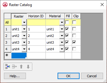
A raster catalog is an attribute table that references [[GMS:Rasters|rasters]] that are currently loaded into the GMS project. Raster catalogs are used for interpolation and to create solids from horizons. | A raster catalog is an attribute table that references [[GMS:Rasters|rasters]] that are currently loaded into the GMS project. Raster catalogs are used for interpolation and to create solids from horizons. | ||
== | ==Create a Raster Catalog== | ||
To create a raster catalog simply select | To create a raster catalog simply select the desired rasters in the Project Explorer, right-click and select the '''New Raster Catalog''' command. | ||
==Interpolation== | ==Interpolation== | ||
