SMS:FESWMS Attributes Dialog: Difference between revisions
From XMS Wiki
Jump to navigationJump to search
No edit summary |
No edit summary |
||
| (2 intermediate revisions by the same user not shown) | |||
| Line 1: | Line 1: | ||
__NOINDEX__ | |||
{{SMS Deprecated Feature}} | |||
The FESWMS map coverage allows attributes to be set for arcs and points. | The FESWMS map coverage allows attributes to be set for arcs and points. | ||
| Line 32: | Line 34: | ||
[[Category:FESWMS|A]] | [[Category:FESWMS|A]] | ||
[[Category:SMS Boundary Conditions|F]] | [[Category:SMS Boundary Conditions|F]] | ||
[[Category:Archived]] | |||
Latest revision as of 14:19, 10 June 2019
| This contains information about features no longer in use for the current release of SMS. The content may not apply to current versions. |
The FESWMS map coverage allows attributes to be set for arcs and points.
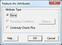
FESWMS Arc Attributes Dialog
The FESWMS Feature Arc Attributes dialog is used to set the attributes for feature arcs. Attributes that can be specified for each feature arc include:
- None – Leaves the arc type as unassigned.
- Boundary Conditions – Options button opens the FESWMS Nodestring Boundary Conditions dialog.
- Continuity Check/Flux –
FESWMS Point Attributes Dialog
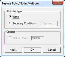
The FESWMS Feature Point/Node Attributes dialog is used to set the attributes for a feature point / refine point represented by a feature point in a 2D mesh model coverage. Attributes that can be specified for each feature point / refine point include:
Attribute Type Frame
- None
- Boundary Conditions – Options button opens the FESWMS Nodal Boundary Conditions dialog.
- FESWMS BC Nodes – FESWMS allows specifying boundary conditions on a nodal basis although it is generally preferable to use boundary conditions on nodestrings. Please refer to the FESWMS manual for information on the nodal boundary condition options.
Options Frame
- Refine point (checked = on)
- Element size – Specify the nodal spacing, or element edge length in the vicinity of the refine point. Refine points are only used if the mesh is generated using the paving or scalar paving density mesh generation methods.
Related Topics
SMS – Surface-water Modeling System | ||
|---|---|---|
| Modules: | 1D Grid • Cartesian Grid • Curvilinear Grid • GIS • Map • Mesh • Particle • Quadtree • Raster • Scatter • UGrid |  |
| General Models: | 3D Structure • FVCOM • Generic • PTM | |
| Coastal Models: | ADCIRC • BOUSS-2D • CGWAVE • CMS-Flow • CMS-Wave • GenCade • STWAVE • WAM | |
| Riverine/Estuarine Models: | AdH • HEC-RAS • HYDRO AS-2D • RMA2 • RMA4 • SRH-2D • TUFLOW • TUFLOW FV | |
| Aquaveo • SMS Tutorials • SMS Workflows | ||

