WMS:Rational Method Edit Parameters: Difference between revisions
No edit summary |
No edit summary |
||
| (23 intermediate revisions by the same user not shown) | |||
| Line 1: | Line 1: | ||
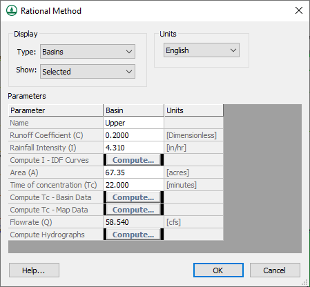
Like the other models supported by WMS, the Rational Method can be defined for a watershed/catchment developed from feature objects, DEMs, or TINs, or built using the tools provided in the hydrologic modeling module under the ''Tree'' menu. Once the topologic tree has been constructed the ''Rational Method'' dialog can be accessed using the '''Run Simulation''' command from the ''Rational'' menu. | [[File:RationalMethodEditParameters.png|thumb|450 px|''Rational Method'' parameters dialog.]] | ||
Like the other models supported by WMS, the Rational Method can be defined for a watershed/catchment developed from feature objects, DEMs, or TINs, or built using the tools provided in the hydrologic modeling module under the ''Tree'' menu. Once the topologic tree has been constructed, the ''Rational Method'' dialog can be accessed using the '''Run Simulation''' command from the ''Rational'' menu. It can also be accessed by selecting a basin or outlet, then right-clicking and selecting the '''Edit Parameters''' menu command. | |||
The ''Rational Method'' dialog allows | The ''Rational Method'' dialog allows entering all of the necessary values for computing a peak flow for a selected catchment area, or confluence point. The values for ''C'', ''i'', and ''A'' represent the values of the currently selected basin or outlet. Options include: | ||
''' | *''Display'' | ||
**''Type'' – Options include "Basins" or "Outlets" which will determine the options in the parameters section below. | |||
**''Show'' – Options include "Selected" or "All". The "Selected" option will on show options for the currently selected outlet or basin. The "All" option will show values for all basins and outlets in the project. | |||
*''Units'' | |||
*''Parameters'' – Section for all values that can be set. Along with the following options, there can be a column for Basin, Outlet, and Unit options depending on how the dialog was reached. | |||
**Name | |||
**Runoff Coefficient | |||
**Rainfall Intensity | |||
**[[WMS:Rational Method Rainfall Intensity|Compute I – IDF Curves]] | |||
**Area | |||
**Time of Concentration | |||
**[[WMS:Travel Times from Basin Data|Compute Tc – Basin Data]] | |||
**[[WMS:Combining Arc Travel Times|Compute Tc – Map Data]] | |||
**Routing Lag Time | |||
**[[WMS:Combining Arc Travel Times|Compute Lag Time]] | |||
**[[WMS:Detention Basin Calculator|Define Reservoir]] | |||
**Flowrate | |||
**[[WMS:Rational Method Computing Hydrographs|Compute Hydrographs]] | |||
==Related Topics== | |||
* [[WMS:Rational Method Basin Data|Basin Data]] | * [[WMS:Rational Method Basin Data|Basin Data]] | ||
* [[WMS:Rational Method Outlet Data|Outlet Data]] | * [[WMS:Rational Method Outlet Data|Outlet Data]] | ||
* [[WMS:Rational Method Rainfall Intensity|Rainfall Intensity]] | * [[WMS:Rational Method Rainfall Intensity|Rainfall Intensity]] | ||
* [[WMS:Rational Method Equation|Rational Method Equation]] | * [[WMS:Rational Method Equation|Rational Method Equation]] | ||
{{WMSMain}} | |||
[[Category:Rational Method|E]] | |||
[[Category:WMS Parameters|R]] | |||
[[Category:Rational Method Dialogs|E]] | |||
Latest revision as of 21:33, 8 June 2023
Like the other models supported by WMS, the Rational Method can be defined for a watershed/catchment developed from feature objects, DEMs, or TINs, or built using the tools provided in the hydrologic modeling module under the Tree menu. Once the topologic tree has been constructed, the Rational Method dialog can be accessed using the Run Simulation command from the Rational menu. It can also be accessed by selecting a basin or outlet, then right-clicking and selecting the Edit Parameters menu command.
The Rational Method dialog allows entering all of the necessary values for computing a peak flow for a selected catchment area, or confluence point. The values for C, i, and A represent the values of the currently selected basin or outlet. Options include:
- Display
- Type – Options include "Basins" or "Outlets" which will determine the options in the parameters section below.
- Show – Options include "Selected" or "All". The "Selected" option will on show options for the currently selected outlet or basin. The "All" option will show values for all basins and outlets in the project.
- Units
- Parameters – Section for all values that can be set. Along with the following options, there can be a column for Basin, Outlet, and Unit options depending on how the dialog was reached.
- Name
- Runoff Coefficient
- Rainfall Intensity
- Compute I – IDF Curves
- Area
- Time of Concentration
- Compute Tc – Basin Data
- Compute Tc – Map Data
- Routing Lag Time
- Compute Lag Time
- Define Reservoir
- Flowrate
- Compute Hydrographs
Related Topics
WMS – Watershed Modeling System | ||
|---|---|---|
| Modules: | Terrain Data • Drainage • Map • Hydrologic Modeling • River • GIS • 2D Grid • 2D Scatter |  |
| Models: | CE-QUAL-W2 • GSSHA • HEC-1 • HEC-HMS • HEC-RAS • HSPF • MODRAT • NSS • OC Hydrograph • OC Rational • Rational • River Tools • Storm Drain • SMPDBK • SWMM • TR-20 • TR-55 | |
| Toolbars: | Modules • Macros • Units • Digitize • Static Tools • Dynamic Tools • Drawing • Get Data Tools | |
| Aquaveo | ||
