WMS:Assigning an Equation: Difference between revisions
No edit summary |
|||
| (17 intermediate revisions by 2 users not shown) | |||
| Line 1: | Line 1: | ||
The ''Basin Time Computation'' dialog allows | [[Image:Basin_Time_Computation_Dialog_WMS.PNG|thumb|400 px|''HEC-1 Basin Time Computation'' dialog]] | ||
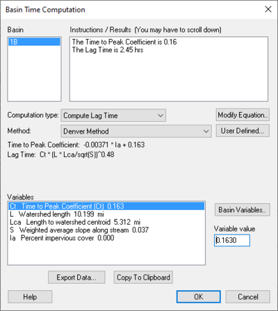
The ''Basin Time Computation'' dialog allows selecting from one of several pre-defined equations. The ''Equation'' drop-down box lists the available methods for computing lag time or time concentration and is controlled by setting the computation type combo box to the desired setting. Once an equation has been selected, the ''Instructions / Results'' window will identify any variables with zero values and instruct to define values for them. Variables are assigned values by selecting the variable from the ''Variables'' text window and then assigning a value to it in the edit box to the right. Once all variables are defined the ''Instructions / Results'' window will display the computed lag time or time of concentration. | |||
==Basin Time Computation Dialog== | |||
Accessed by selecting '''Compute Parameters-Basin Data''' in the ''HEC-1 Unit Hydrograph Methods'' dialog. | |||
''Basin'' – | |||
''Instructions / Results (You may have to scroll down)'' – | |||
''Computational type:'' – | |||
{| class="wikitable mw-collapsible mw-collapsed" | |||
|+ class="nowrap" | "Compute Lag Time" | |||
|- | |||
| | |||
! scope="col" | Selections | |||
! scope+"col" | Selection Options | |||
|- | |||
! scope="row" | | |||
| ''Method:'' ||"Denver Method" | |||
"Tulsa Rural Method" | |||
"Tulsa 50% Urban Method" | |||
"Tulsa 100% Urban Method" | |||
"Espey Rural Method" | |||
"Espey No Urbanization Method" | |||
"Espey Partly Urban Method" | |||
"Espey Completely Urban Method" | |||
"Riverside Mountains Method" | |||
"Riverside Foothills Method" | |||
"Eagleson Method" | |||
"USGS Nationwide Urban Method" | |||
"Putnam Method" | |||
"Taylor Method" | |||
"Colorado State University (CSU) Method" | |||
"Scs Method" | |||
"Custom Method" | |||
|- | |||
! scope="row" | | |||
| '''User Defined...''' – || Select to bring up ''Modify Equation'' dialog. | |||
|- | |||
! scope="row" | | |||
|'''Modify Equation...''' || Select to bring up the ''Modify Equation'' dialog that allows you to modify the equation used for the Basin time computation. | |||
|- | |||
! scope="row" | | |||
|'''Basin Variables...''' –|| Select to open the ''Basin Geometric Attributes'' dialog. | |||
| | |||
|} | |||
{| class="wikitable mw-collapsible mw-collapsed" | |||
|+ class="nowrap" | "Compute Time of Concentration" | |||
|- | |||
| | |||
! scope="col" | Selections | |||
! scope+"col" | Selection Options | |||
|- | |||
! scope="row" | | |||
| ''Method:'' ||"User Defined Method" | |||
"Kirpich Method for overland flow on bare earth" | |||
"Kirpich Method for overland flow on grassy earth" | |||
"Kirpich Method for overland flow on asphalt" | |||
"Kirpich Method for overland flow on bare earth (Mountains)" | |||
"Kirpich Method for overland flow on grassy earth (Mountains)" | |||
"Kirpich Method for overland flow on asphalt (Mountains)" | |||
"Ramser Method for channel flow" | |||
"Fort Bend County Method" | |||
"Kerby Method for overland flow" | |||
"ADOT Method (Desert/Mountain)" | |||
"ADOT Method (Urban)" | |||
|- | |||
! scope="row" | | |||
| '''User Defined...''' – || Select to bring up ''Modify Equation'' dialog. | |||
|- | |||
! scope="row" | | |||
|'''Modify Equation...''' || Select to bring up the ''Modify Equation'' dialog that allows you to modify the equation used for the Basin time computation. | |||
|- | |||
! scope="row" | | |||
|'''Basin Variables...''' –|| Select to open the ''Basin Geometric Attributes'' dialog. | |||
| | |||
|} | |||
''Units'' – The units that apply to the definition chosen. | |||
*"none" | |||
*"ft" | |||
*"m" | |||
*"km" | |||
*"mi" | |||
*hr" | |||
*"min" | |||
*"sec" | |||
*"sq. mi" | |||
*"sq. km" | |||
*"sq. ft" | |||
*"acre" | |||
*"hect" | |||
*"in" | |||
*"mm" | |||
*"ft/mi" | |||
*"fract" | |||
''Method:'' – Estimation of the channel velocity measured in feet per second. | |||
''Variable Value'' – Enter the variable value. | |||
'''Export Data''' – When is selected a dialog will appear that will ask whether you want to append to an existing file or export a new one. | |||
'''Copy to Clipboard''' – Select to copy to clip board. | |||
==WMS:Basin Geometric Attributes Dialog== | |||
Accessed by selecting '''Basin Geometrical Attributes''' located in the ''HEC-1 Unit Hydrograph Methods'' dialog. | |||
Variable Names – Below the Variable Names heading is a table that allows the inputting of values for each one of the listed variables' names. | |||
[[Image:Basin_Geometric_Attributes_dialog_WMS.PNG|thumb|none|left|500 px|''HEC-1 Basin Geometric Attributes'' dialog]] | |||
'''Recompute Basin Data''' – Select to bring up the [[WMS:Units Toolbar|''Units'' dialog]]. | |||
'''Restore Original Values''' – Select to revert all values in the Variable Names table back to their original values. | |||
==Related Topics== | ==Related Topics== | ||
* [[WMS:Overview of Basin Data Equations|Overview of Basin Data Equations]] | * [[WMS:Overview of Basin Data Equations|Overview of Basin Data Equations]] | ||
* [[WMS:Travel Times from Basin Data|Travel Times from Basin Data]] | * [[WMS:Travel Times from Basin Data|Travel Times from Basin Data]] | ||
{{WMSMain}} | {{WMSMain}} | ||
[[Category:Equations| | [[Category:Equations|Assigning]] | ||
[[Category:WMS Basins|Assigning]] | |||
{{stub}} | |||
Latest revision as of 22:01, 9 June 2020
The Basin Time Computation dialog allows selecting from one of several pre-defined equations. The Equation drop-down box lists the available methods for computing lag time or time concentration and is controlled by setting the computation type combo box to the desired setting. Once an equation has been selected, the Instructions / Results window will identify any variables with zero values and instruct to define values for them. Variables are assigned values by selecting the variable from the Variables text window and then assigning a value to it in the edit box to the right. Once all variables are defined the Instructions / Results window will display the computed lag time or time of concentration.
Basin Time Computation Dialog
Accessed by selecting Compute Parameters-Basin Data in the HEC-1 Unit Hydrograph Methods dialog. Basin – Instructions / Results (You may have to scroll down) – Computational type: –
| Selections | Selection Options | ||
|---|---|---|---|
| Method: | "Denver Method"
"Tulsa Rural Method" "Tulsa 50% Urban Method" "Tulsa 100% Urban Method" "Espey Rural Method" "Espey No Urbanization Method" "Espey Partly Urban Method" "Espey Completely Urban Method" "Riverside Mountains Method" "Riverside Foothills Method" "Eagleson Method" "USGS Nationwide Urban Method" "Putnam Method" "Taylor Method" "Colorado State University (CSU) Method" "Scs Method" "Custom Method" | ||
| User Defined... – | Select to bring up Modify Equation dialog. | ||
| Modify Equation... | Select to bring up the Modify Equation dialog that allows you to modify the equation used for the Basin time computation. | ||
| Basin Variables... – | Select to open the Basin Geometric Attributes dialog. |
| Selections | Selection Options | ||
|---|---|---|---|
| Method: | "User Defined Method"
"Kirpich Method for overland flow on bare earth" "Kirpich Method for overland flow on grassy earth" "Kirpich Method for overland flow on asphalt" "Kirpich Method for overland flow on bare earth (Mountains)" "Kirpich Method for overland flow on grassy earth (Mountains)" "Kirpich Method for overland flow on asphalt (Mountains)" "Ramser Method for channel flow" "Fort Bend County Method" "Kerby Method for overland flow" "ADOT Method (Desert/Mountain)" "ADOT Method (Urban)" | ||
| User Defined... – | Select to bring up Modify Equation dialog. | ||
| Modify Equation... | Select to bring up the Modify Equation dialog that allows you to modify the equation used for the Basin time computation. | ||
| Basin Variables... – | Select to open the Basin Geometric Attributes dialog. |
Units – The units that apply to the definition chosen.
- "none"
- "ft"
- "m"
- "km"
- "mi"
- hr"
- "min"
- "sec"
- "sq. mi"
- "sq. km"
- "sq. ft"
- "acre"
- "hect"
- "in"
- "mm"
- "ft/mi"
- "fract"
Method: – Estimation of the channel velocity measured in feet per second.
Variable Value – Enter the variable value.
Export Data – When is selected a dialog will appear that will ask whether you want to append to an existing file or export a new one.
Copy to Clipboard – Select to copy to clip board.
WMS:Basin Geometric Attributes Dialog
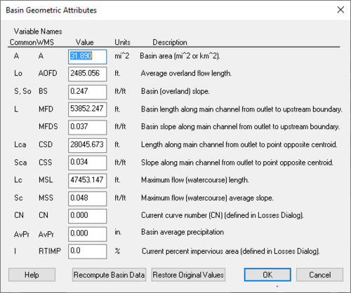
Accessed by selecting Basin Geometrical Attributes located in the HEC-1 Unit Hydrograph Methods dialog. Variable Names – Below the Variable Names heading is a table that allows the inputting of values for each one of the listed variables' names.
Recompute Basin Data – Select to bring up the Units dialog.
Restore Original Values – Select to revert all values in the Variable Names table back to their original values.
Related Topics
WMS – Watershed Modeling System | ||
|---|---|---|
| Modules: | Terrain Data • Drainage • Map • Hydrologic Modeling • River • GIS • 2D Grid • 2D Scatter |  |
| Models: | CE-QUAL-W2 • GSSHA • HEC-1 • HEC-HMS • HEC-RAS • HSPF • MODRAT • NSS • OC Hydrograph • OC Rational • Rational • River Tools • Storm Drain • SMPDBK • SWMM • TR-20 • TR-55 | |
| Toolbars: | Modules • Macros • Units • Digitize • Static Tools • Dynamic Tools • Drawing • Get Data Tools | |
| Aquaveo | ||

