WMS:OC Rational Sub-area Data: Difference between revisions
From XMS Wiki
Jump to navigationJump to search
No edit summary |
No edit summary |
||
| Line 9: | Line 9: | ||
'''% Nonmountainous and % Mountainous:''' The percentage of the sub-area that lies below and above 2000 ft, respectively. Use the Compute % Mountainous button to calculate these values using a DEM or TIN. | '''% Nonmountainous and % Mountainous:''' The percentage of the sub-area that lies below and above 2000 ft, respectively. Use the Compute % Mountainous button to calculate these values using a DEM or TIN. | ||
===Initial Sub-area=== | |||
* '''Tc:''' The time of concentration (min) | |||
* '''Intensity:''' The rainfall intensity (in/hr) is automatically computed based on the Tc | |||
===Losses=== | |||
* '''ap:''' Pervious area percentage | |||
* '''Fp:''' Pervious area loss rate | |||
* '''Fm:''' Maximum area [[WMS:OC Losses|loss rate]] | |||
*:Calculate Fm by toggling on the Compute Fm checkbox, entering values for ap and Fp, and using the Compute Fm button or click on the Compute Fm - GIS button to use GIS data. | |||
Revision as of 23:34, 13 February 2013
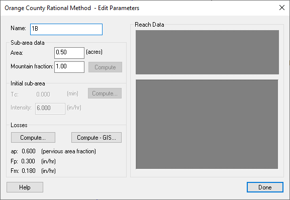
When setting up a Orange County Rational Method simulation, data must be entered for each sub-area.
Area: The sub-area area (acres or ha.) can be automatically computed when using a DEM or TIN
% Nonmountainous and % Mountainous: The percentage of the sub-area that lies below and above 2000 ft, respectively. Use the Compute % Mountainous button to calculate these values using a DEM or TIN.
Initial Sub-area
- Tc: The time of concentration (min)
- Intensity: The rainfall intensity (in/hr) is automatically computed based on the Tc
Losses
- ap: Pervious area percentage
- Fp: Pervious area loss rate
- Fm: Maximum area loss rate
- Calculate Fm by toggling on the Compute Fm checkbox, entering values for ap and Fp, and using the Compute Fm button or click on the Compute Fm - GIS button to use GIS data.
Related Topics
- Losses
- Initial Sub-area Time of Concentration
- Orange County Rational Equation
- Orange County Rational Method
- Reach Routing
- Creating Watershed Models
WMS – Watershed Modeling System | ||
|---|---|---|
| Modules: | Terrain Data • Drainage • Map • Hydrologic Modeling • River • GIS • 2D Grid • 2D Scatter |  |
| Models: | CE-QUAL-W2 • GSSHA • HEC-1 • HEC-HMS • HEC-RAS • HSPF • MODRAT • NSS • OC Hydrograph • OC Rational • Rational • River Tools • Storm Drain • SMPDBK • SWMM • TR-20 • TR-55 | |
| Toolbars: | Modules • Macros • Units • Digitize • Static Tools • Dynamic Tools • Drawing • Get Data Tools | |
| Aquaveo | ||
