WMS:What's new in WMS version 8.2: Difference between revisions
m (Protected "WMS:What's new in WMS version 8.2" ([Edit=Allow only administrators] (indefinite) [Move=Allow only administrators] (indefinite))) |
|
(No difference)
| |
Revision as of 14:27, 12 September 2016
The WMS software development team is excited about the release of WMS 8.2! This page lists the exciting new features that have been added to WMS 8.2.
Model Enhancements
Hydrologic Modeling
Support of calibration and batch mode processes (stochastic modeling) in the GSSHA interface
Using WMS 8.2, you can run GSSHA in calibration mode to determine optimum parameters or in batch mode to run using a range of input values.
Improved stream model checker, better stream visualization, stream adjustment to match grid, and improved stream smoothing
The hydrologic modeling wizard has been improved in WMS 8.2 to allow for editing stream elevations before creating a 2D grid. When the 2D grid is generated, the grid cell elevations are set to match the stream elevations. Matching up these elevations reduces the chance for errors in running your GSSHA model when stream routing is defined.
Ability to create multiple GSSHA scenarios (multiple GSSHA job controls, sets of index maps, mapping tables, solutions, etc.)
Multiple scenarios, such pre-development and post-development conditions, can be defined in a single instance of WMS. Each of these scenarios can be run and the results from each scenario can be compared.
Support of wetlands, sediment transport, and groundwater/surfacewater interaction routines in GSSHA
WMS 8.2 contains full support for wetland, sediment transport, and groundwater/surfacewater interaction capabilities in GSSHA. Tutorials for each of these capabilities are available on gsshawiki.com.
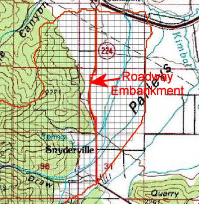
Improved ability for defining embankment arcs
WMS 8.2 has improved ability for defining embankment arcs and running GSSHA embankment routines that was not available in previous version of WMS.
Hydraulic Modeling
Support of HEC-RAS 4.0 and sediment transport
WMS 8.2 contains support for the latest version of HEC-RAS, version 4.0, which has sediment transport capabilities.
General Enhancements
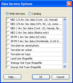
Improved web service client tools
WMS 8.2 Includes all types of NED and SRTM elevation data downloads, Terraserver images, and a web catalog that allows you to download any type of data if the data is available. These data sets can be downloaded directly from WMS and from the hydrologic modeling wizard. In WMS 8.2, practically all of the data required for a hydrologic study can be downloaded directly from WMS for any location in the world.
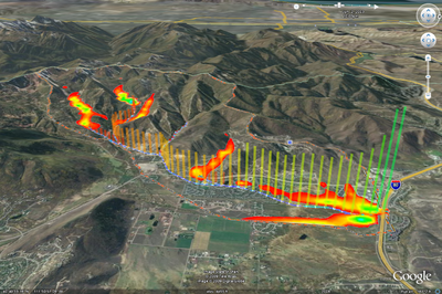
Output animated KMZ files to Google Earth
One of the results from running a GSSHA model is water depth at any location of your watershed for any time during your simulation. With WMS 8.2, you can export an animation of the water depth contours and any other parameter that is computed in GSSHA to a file that can be read by Google Earth. This capability is great for presentations of GSSHA model results.
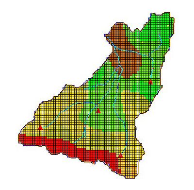
Dataset zonal classification
Using WMS 8.2, you can combine datasets such as erosion and deposition to view areas of low erosion and high deposition or high erosion and low deposition based on certain criteria. You can view the results of these queries throughout your watershed.
WMS – Watershed Modeling System | ||
|---|---|---|
| Modules: | Terrain Data • Drainage • Map • Hydrologic Modeling • River • GIS • 2D Grid • 2D Scatter |  |
| Models: | CE-QUAL-W2 • GSSHA • HEC-1 • HEC-HMS • HEC-RAS • HSPF • MODRAT • NSS • OC Hydrograph • OC Rational • Rational • River Tools • Storm Drain • SMPDBK • SWMM • TR-20 • TR-55 | |
| Toolbars: | Modules • Macros • Units • Digitize • Static Tools • Dynamic Tools • Drawing • Get Data Tools | |
| Aquaveo | ||


