WMS:NSS Region Coverage: Difference between revisions
From XMS Wiki
Jump to navigationJump to search
No edit summary |
No edit summary |
||
| Line 28: | Line 28: | ||
[[Category:WMS Coverages|N]] | [[Category:WMS Coverages|N]] | ||
[[Category:External Links]] | [[Category:External Links]] | ||
[[Category:NSS]] | [[Category:NSS|Region]] | ||
[[Category:NSS Dialogs]] | [[Category:NSS Dialogs|Region]] | ||
Latest revision as of 15:10, 26 October 2016
An NSS Region coverage can be generated so that regions can automatically be mapped to a drainage coverage when performing hydrologic analysis using the NSS regression equations. Individual state maps can be found at the USGS website: http://water.usgs.gov/software/NSS/ (Look at the bottom of the page and select the state).
If wanting to digitize the state:
- Download the image from the USGS website and save the picture as either a *.tif or *.jpg image (many times the default will be a *.gif image) using any type of imaging software program.
- Load the *.tif, or *.jpg image into WMS and register according to the latitude and longitude coordinates found on the map.
- Then convert the coordinates to the coordinate system that will be used in delineating the watershed in.
- With the image in the background, digitize the lines and build the polygons of the coverage.
- Finally assign the attributes (state and region) to the polygons and save it as a map file.
This NSS coverage file can then be used for any watershed within the given state.
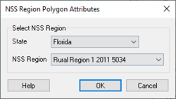
NSS Region Polygon Attributes Dialog
Selecting a polygon in the NSS Region coverage and the using the Feature Objects | Attributes command will bring up the NSS Region Polygon Attributes dialog. The dialog allows assigning the following:
- State – Provides a list of U.S. States.
- NSS Region – Provides a list of available regions based on the state selected above.
For more information on the data available in each NSS region, see the NSS regional documentation.
Related Topics
WMS – Watershed Modeling System | ||
|---|---|---|
| Modules: | Terrain Data • Drainage • Map • Hydrologic Modeling • River • GIS • 2D Grid • 2D Scatter |  |
| Models: | CE-QUAL-W2 • GSSHA • HEC-1 • HEC-HMS • HEC-RAS • HSPF • MODRAT • NSS • OC Hydrograph • OC Rational • Rational • River Tools • Storm Drain • SMPDBK • SWMM • TR-20 • TR-55 | |
| Toolbars: | Modules • Macros • Units • Digitize • Static Tools • Dynamic Tools • Drawing • Get Data Tools | |
| Aquaveo | ||
