WMS:TR-20 Edit Parameters: Difference between revisions
No edit summary |
|||
| Line 1: | Line 1: | ||
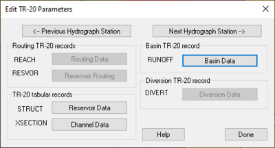
[[File:TR20parameters. | [[File:TR20parameters.png|thumb|400 px|Example of the ''Edit TR-20 Parameters'' dialog.]] | ||
Attributes or parameters for all TR-20 hydrograph stations are defined and/or later edited using the ''Edit TR-20 Parameters'' dialog. | Attributes or parameters for all TR-20 hydrograph stations are defined and/or later edited using the ''Edit TR-20 Parameters'' dialog. | ||
Latest revision as of 20:58, 13 December 2023
Attributes or parameters for all TR-20 hydrograph stations are defined and/or later edited using the Edit TR-20 Parameters dialog.
If a basin, outlet, or diversion is selected before issuing the command then data for that object is loaded for editing. This dialog lists the TR-20 hydrograph station parameters which can be edited by selecting the corresponding button. When a hydrograph station is selected (basins/outlets/reservoirs/diversions) only the buttons which edit parameters associated with that hydrograph station are active, all others are dimmed.
Edit TR-20 Parameters Dialog
This dialog is accessed by selecting the Edit TR-20 Parameters command from the TR-20 menu or when TR-20 is the active model by double-clicking on basin, outlet, or diversion from the Graphics Window.
Once the dialog appears it becomes part of the main screen until selecting the Done button. Therefore, continue to select additional, or other, hydrograph stations so that data for that object may be edited without exiting the dialog. Use the Previous and Next Hydrograph Station buttons to cycle through hydrograph stations in the order they are computed by TR-20. While the dialog is up, all menu commands are active.
- Previous Hydrograph Station – Select to open the previous hydrograph station.
- Routing TR-20 Records – This is the section where the routing records for the project are entered.
- REACH – Reach data.
- Routing Data – Select to enter the routing data associated with the project.
- RESVOR – Reservoir data.
- Reservoir Data – Select to enter the reservoir data associated with the project.
- REACH – Reach data.
- TR-20 Tabular Records – This section is where the tabular records are entered.
- STRUCT – Structure data.
- Reservoir Data – Select to define the reservoir data.
- XSECTION – Cross Section data.
- Channel Data – Select to define the channel data.
- STRUCT – Structure data.
- Next Hydrograph Station – Select to open up the next hydrograph station.
- Basin TR-20 Record – This section is where the basin records for the project are entered.
- RUNOFF – Runoff data.
- Basin Data – Select to define the basin data.
- RUNOFF – Runoff data.
- Diversion TR-20 Record – This is the section where the diversion records for the project are entered.
- DIVERT – Diversion data.
- Diversion Data – Select to define the recorded diversion data.
- DIVERT – Diversion data.
Related Topics
- TR-20 Overview
- Entering Job Control Parameters
- Entering Basin Data
- Entering Routing Data
- Entering Reservoir Data
- Entering Diversion Data
- Output Control
WMS – Watershed Modeling System | ||
|---|---|---|
| Modules: | Terrain Data • Drainage • Map • Hydrologic Modeling • River • GIS • 2D Grid • 2D Scatter |  |
| Models: | CE-QUAL-W2 • GSSHA • HEC-1 • HEC-HMS • HEC-RAS • HSPF • MODRAT • NSS • OC Hydrograph • OC Rational • Rational • River Tools • Storm Drain • SMPDBK • SWMM • TR-20 • TR-55 | |
| Toolbars: | Modules • Macros • Units • Digitize • Static Tools • Dynamic Tools • Drawing • Get Data Tools | |
| Aquaveo | ||
