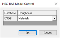
WMS:HEC-RAS Model Control
From XMS Wiki
Jump to navigationJump to search
When materials are mapped to cross sections a material ID is stored for the line segment properties. In order to properly link the material ID with a roughness when exporting the GIS file for HEC-RAS an Area Property coverage must be linked to a cross section database. The Model Control dialog allows making this specification. If no definition has been provided when exporting the GIS file, a prompt will ask to make the association before proceeding with the export.
Related Topics
WMS – Watershed Modeling System | ||
|---|---|---|
| Modules: | Terrain Data • Drainage • Map • Hydrologic Modeling • River • GIS • 2D Grid • 2D Scatter |  |
| Models: | CE-QUAL-W2 • GSSHA • HEC-1 • HEC-HMS • HEC-RAS • HSPF • MODRAT • NSS • OC Hydrograph • OC Rational • Rational • River Tools • Storm Drain • SMPDBK • SWMM • TR-20 • TR-55 | |
| Toolbars: | Modules • Macros • Units • Digitize • Static Tools • Dynamic Tools • Drawing • Get Data Tools | |
| Aquaveo | ||
