WMS:Feature Selection: Difference between revisions
| (10 intermediate revisions by the same user not shown) | |||
| Line 1: | Line 1: | ||
With ArcObjects enabled three different selection methods are available. However, before attempting to select layers | With ArcObjects enabled three different selection methods are available. However, before attempting to select layers, make sure that the layer(s) to be used are selectable. By default a layer is selectable when opened, but the status can be changed to unselectable using the '''Selectable Layers''' command in the ''Selection'' menu. | ||
==Graphical Selection== | ==Graphical Selection== | ||
The | The '''Select Features''' tool can be used to interactively select features from GIS layers. When selecting using graphical selection all features from all selectable layers will be added to the selection list. A rectangular box can be dragged around a region of interest and then all features from all selectable layers that have in part within the rectangle will be added to the selection list. | ||
The '''Options''' command is used to specify how features are selected and the way they are displayed. | The '''Options''' command is used to specify how features are selected and the way they are displayed. | ||
| Line 9: | Line 9: | ||
==Selection by Attribute== | ==Selection by Attribute== | ||
Features of a layer can also be selected based on a query of the attributes and their values. The ''Query Wizard'' is used to choose the layer | Features of a layer can also be selected based on a query of the attributes and their values. The ''Query Wizard'' is used to choose the layer to select from and the way the query results will be treated. The query can create a new selection, add to the current selection, remove from the current selection, or select on from within currently selected features. | ||
<gallery widths="350px" heights="260 px"> | |||
Image:GISquery wizard.png|GIS ''Query Wizard'' first step. | |||
File:GISquery wizard2.png|GIS ''Query Wizard'' second step. | |||
File:GISquery wizard3.png|GIS ''Query Wizard'' third step. | |||
</gallery> | |||
==Selection by Location== | ==Selection by Location== | ||
Select features from one or more GIS layers based on their spatial relationship to another layer. The ''Select By Location'' dialog allows specifying whether to select new features, add to currently selected features, select from selected features, or delete from selected features. In addition, it specifies the layers to be selected from as well as the relationship with the selection layer. Finally, specify the layer used for selection and whether to use all features or only selected features. A buffer distance can be added to the features of the selection layer. | |||
:[[Image:GIS Select by Location.png|350 px]] | :[[Image:GIS Select by Location.png|350 px]] | ||
| Line 30: | Line 32: | ||
{{WMSMain}} | {{WMSMain}} | ||
[[Category:WMS GIS|F]] | [[Category:WMS GIS|F]] | ||
[[Category:WMS Dialogs | [[Category:WMS GIS Dialogs]] | ||
[[Category:Gallery]] | |||
Latest revision as of 17:31, 2 October 2017
With ArcObjects enabled three different selection methods are available. However, before attempting to select layers, make sure that the layer(s) to be used are selectable. By default a layer is selectable when opened, but the status can be changed to unselectable using the Selectable Layers command in the Selection menu.
Graphical Selection
The Select Features tool can be used to interactively select features from GIS layers. When selecting using graphical selection all features from all selectable layers will be added to the selection list. A rectangular box can be dragged around a region of interest and then all features from all selectable layers that have in part within the rectangle will be added to the selection list.
The Options command is used to specify how features are selected and the way they are displayed.

Selection by Attribute
Features of a layer can also be selected based on a query of the attributes and their values. The Query Wizard is used to choose the layer to select from and the way the query results will be treated. The query can create a new selection, add to the current selection, remove from the current selection, or select on from within currently selected features.
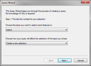
GIS Query Wizard first step.
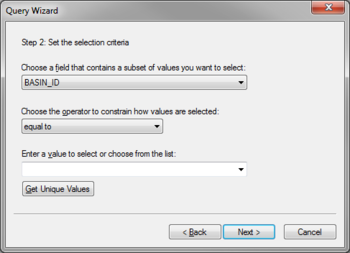
GIS Query Wizard second step.
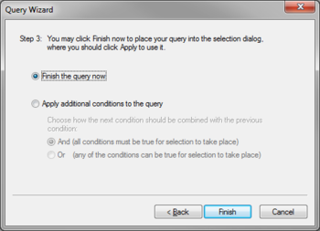
GIS Query Wizard third step.


Selection by Location
Select features from one or more GIS layers based on their spatial relationship to another layer. The Select By Location dialog allows specifying whether to select new features, add to currently selected features, select from selected features, or delete from selected features. In addition, it specifies the layers to be selected from as well as the relationship with the selection layer. Finally, specify the layer used for selection and whether to use all features or only selected features. A buffer distance can be added to the features of the selection layer.

Clearing Selected Features
The Clear Selected Features command clears all features from the selection list.
Related Topics
WMS – Watershed Modeling System | ||
|---|---|---|
| Modules: | Terrain Data • Drainage • Map • Hydrologic Modeling • River • GIS • 2D Grid • 2D Scatter |  |
| Models: | CE-QUAL-W2 • GSSHA • HEC-1 • HEC-HMS • HEC-RAS • HSPF • MODRAT • NSS • OC Hydrograph • OC Rational • Rational • River Tools • Storm Drain • SMPDBK • SWMM • TR-20 • TR-55 | |
| Toolbars: | Modules • Macros • Units • Digitize • Static Tools • Dynamic Tools • Drawing • Get Data Tools | |
| Aquaveo | ||