WMS:MODRAT Creating Burned Simulations
Wildfires frequently burn undeveloped watersheds. Infiltrometer tests conducted in burned chaparral-covered mountain watersheds indicate that these watersheds suffer from a decreased infiltration rate after a fire. The decrease results from calcification caused by intense heat, plugging of the soil pores by ash or other fines, and other chemical reactions that produce a hydrophobic condition. A lack of surface cover also promotes the formation of a crust of fine soil due to the impact of raindrops. This crust further impedes infiltration.
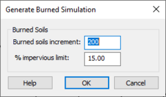
Burned soil simulations can be created using existing normal soil simulations using the Generate Burned Simulation dialog. The dialog is reached through the Create Burned Simulation command in the MODRAT menu.
For the Burned soils increment enter the difference between the existing soil numbers and burned soil numbers in the soil file (lasoilx.dat). WMS increments the soil number so that it will be a burned soil for each sub-basin with a percent impervious value less than the percent impervious limit specified in this dialog. Save the *.lac file to use the burned soil numbers in the simulation. Be sure to save the *.lac file with a different name before creating a burned simulation if wanting to keep the normal soil simulation.
Related Topics
| [hide] WMS – Watershed Modeling System | ||
|---|---|---|
| Modules: | Terrain Data • Drainage • Map • Hydrologic Modeling • River • GIS • 2D Grid • 2D Scatter |  |
| Models: | CE-QUAL-W2 • GSSHA • HEC-1 • HEC-HMS • HEC-RAS • HSPF • MODRAT • NSS • OC Hydrograph • OC Rational • Rational • River Tools • Storm Drain • SMPDBK • SWMM • TR-20 • TR-55 | |
| Toolbars: | Modules • Macros • Units • Digitize • Static Tools • Dynamic Tools • Drawing • Get Data Tools | |
| Aquaveo | ||
