GMS:LAK Package: Difference between revisions
From XMS Wiki
Jump to navigationJump to search
No edit summary |
|||
| (5 intermediate revisions by 2 users not shown) | |||
| Line 6: | Line 6: | ||
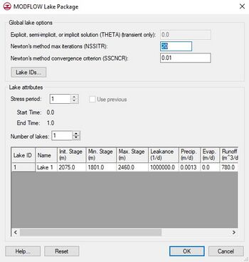
The Lake package includes an option that allows one to simulate "sublakes". This option makes it possible for the lake to partition into smaller, separated lakes as the lake stage drops. | The Lake package includes an option that allows one to simulate "sublakes". This option makes it possible for the lake to partition into smaller, separated lakes as the lake stage drops. | ||
The Theta term offers a choice between an explicit solution at 0.0, a semi-implicit solution between 0.0 and 1.0, or an implicit solution at 1.0 | The Theta term offers a choice between an explicit solution at 0.0, a semi-implicit solution between 0.0 and 1.0, or an implicit solution at 1.0. | ||
For using the LAK package with MODFLOW-USG, the grid should have the same topology in all layers through which the water table fluctuates. | |||
[[File:MODFLOW-Lake.jpg|thumb|none|left|350 px|The ''MODFLOW Lake Package'' dialog.]] | [[File:MODFLOW-Lake.jpg|thumb|none|left|350 px|The ''MODFLOW Lake Package'' dialog.]] | ||
| Line 16: | Line 18: | ||
*''Withdrawal'' – The volumetric rate, or flux, of water removal from a lake by means other than rainfall, evaporation, surface outflow, or ground-water seepage. | *''Withdrawal'' – The volumetric rate, or flux, of water removal from a lake by means other than rainfall, evaporation, surface outflow, or ground-water seepage. | ||
==Adjust Cell | ==Adjust Cell Elevation== | ||
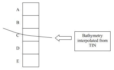
Lake polygons in a [[GMS:MODFLOW_Conceptual_Model_Approach|conceptual model]] include an option called ''Adjust Cell Elev.'' This option often results in thin cells and instability and should generally be avoided. Here's how it works. GMS interpolates a bathymetric elevation from the appropriate TIN and finds the cell where the top of the cell is above the bathymetric elevation and the bottom of the cell is below. After finding the intersecting cell, all cells above the point in question are marked as inactive (IBOUND = 0) and assigned with the appropriate lake ID. For the cell that intersects the bottom of the lake, the way the cell is handled depends on what layer it is in. If the cell is in the top layer, it is made inactive, marked as part of the lake, and the bottom elevation of the cell is adjusted to match the lake bottom. If the cell is in one of the lower layers, GMS first determines if the lake bottom is closer to the top of the cell or the bottom of the cell. If the lake bottom is closer to the top of the cell, the top elevation for the cell is adjusted to match the bottom of the lake and the cell is left as active and NOT marked as being in the interior of the lake. If the lake bottom is closer to the bottom of the cell, the bottom elevation of the cell is adjusted to match the lake bottom and the cell is marked as both inactive and inside of the lake. | Lake polygons in a [[GMS:MODFLOW_Conceptual_Model_Approach|conceptual model]] include an option called ''Adjust Cell Elev.'' This option often results in thin cells and instability and should generally be avoided. Here's how it works. GMS interpolates a bathymetric elevation from the appropriate TIN and finds the cell where the top of the cell is above the bathymetric elevation and the bottom of the cell is below. After finding the intersecting cell, all cells above the point in question are marked as inactive (IBOUND = 0) and assigned with the appropriate lake ID. For the cell that intersects the bottom of the lake, the way the cell is handled depends on what layer it is in. If the cell is in the top layer, it is made inactive, marked as part of the lake, and the bottom elevation of the cell is adjusted to match the lake bottom. If the cell is in one of the lower layers, GMS first determines if the lake bottom is closer to the top of the cell or the bottom of the cell. If the lake bottom is closer to the top of the cell, the top elevation for the cell is adjusted to match the bottom of the lake and the cell is left as active and NOT marked as being in the interior of the lake. If the lake bottom is closer to the bottom of the cell, the bottom elevation of the cell is adjusted to match the lake bottom and the cell is marked as both inactive and inside of the lake. | ||

